Symonds Yat, High Meadow Woods & Wye Valley
Wye Valley Forest of Dean Walk
Region - Wye Valley Forest of Dean
County/Area - Gloucestershire & Monmouthshire & Herefordshire
Author - Andy Smith & Peter Lane
Length - 12.0 miles / 19.5 km Ascent - 2700 feet / 818 metres
Time - 8 hours 40 minutes Grade - moderate
Maps 

| Ordnance Survey Explorer OL14 | Sheet Map | 1:25k | BUY |
| Anquet OS Explorer OL14 | Digital Map | 1:25k | BUY |
| Ordnance Survey Landranger 162 | Sheet Map | 1:50k | BUY |
| Anquet OS Landranger 162 | Digital Map | 1:50k | BUY |
Walk Route Description
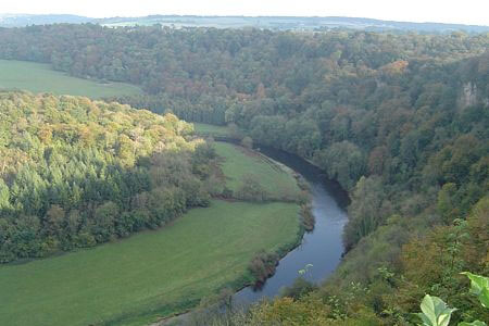
Click image to visit gallery of 12 images.
The Forest of Dean lies between the rivers Wye and Severn and spans the borders of Wales and England. This stunning 110 square kilometre woodland is one of the few remaining areas of ancient woodland in the UK and attracts many visitors each year.
Despite its huge weekend popularity, there is still a selection of fine walks away from the crowds. This route takes in the quieter option of High Meadow woods, leaving England into Wales before the highlight of the day, Yat Rock viewpoint. The paths are very well defined, however good navigational skills are required as sections are poorly marked at times and littered with options. A compass is essential to ensure that you do not stray from the correct path.
There is a large pay & display car park at grid reference SO564156. It is worth crossing the road bridge from the car park to take a quick look at the viewpoint at Yat Rock, just in case it is clouded over later when you come back.
From the car park, exit to the south on a small track that runs alongside the B4432 for a hundred meters. After a few minutes this crosses the car park exit road before taking you deep into the forest. After a while the track swings close to the road and a telephone box, take a right here along the forestry vehicle track passing another car park. When the stream is crossed take the left-hand fork and join the main track heading due west, you are now on the Wysis Way heading for the town of Monmouth. Within 10 minutes of joining the trail the route turns left at an unmarked junction which can be typical of the Wysis Way. This is a small, narrow track, but can be determined by its consistent Westerly bearing.
Despite having leisure path status, the Wysis Way is poorly and sporadically marked. Maintain a generally Westerly bearing, resisting the temptation to be seduced down wider paths. Ignore all the crossing forestry roads and head towards Suck Stone through some dense woods. After half an hour Suck Stone is finally reached at a precipice.
At Suck Stone you will be rewarded with stunning views across the Wye Valley to the Black Mountains of Wales in the distance making it a good choice for a lunch break! Once the photo opportunity has been taken, leave the viewpoint to the right where an indistinct path leads you under the rock and into the valley. Here the rock formation offers a surprising treat as the route passes directly underneath in a cave like fashion! Continue downhill where the track runs onto another vehicle access road heading SSE towards Staunton village. After a while the Wysis Way crosses the A4136 towards Kymin. Care should be taken here as traffic moves fast made worse by a blind summit to the left.
Cross the road and depart the Wysis Way after about 500 meters, continuing along the broad path until the route takes a sharp left, turning south. Here head straight on down a narrow footpath along a similar bearing to your approach. Continue to a complex junction of stiles and cross over one stile on the left and then immediately right down an overgrown section of path. This emerges, after a downhill section, at a private garden. Cross with care; ring the bell to call off the owner's dogs if you are of a nervous disposition!
Now turn right along the country lane and follow it downhill to the main A4136. Turn left along this and follow it into Monmouth, crossing the River Wye over the road bridge. Turn right along the opposite bank of the Wye and connect up with the Wye Valley Way. The going is now very straightforward as you follow the river and A40 passing Hadnock Court. The river and path turns sharply eastbound which gives a refreshing break from the road as you set a good pace towards Biblins Bridge.
Cross the suspension bridge and turn left following the river past the rapids and into Symonds Yat village. The Saracen's Head pub makes a very pleasant meal break after this hard walk overlooking the river Wye and the ferry. Leave the pub to the right heading up the lane to the small hotel, take the left path by the fence and head directly uphill out of the gorge. Once climbed, cross the tiny road bridge from the car park and turn left to the obvious viewpoint where on a fine day you will be rewarded with views of the river Wye and Welsh borders.
Once finished exit the viewpoint to the south crossing the bridge, past the gift shop and back into the car park you started from. A fine introduction into the Royal Forest of Dean is completed.
Other walks nearby
| Walk 2832 | The Wye Valley | easy/mod | 5.8 miles |
| Walk 3243 | Garway Hill Common & Kentchurch | easy/mod | 6.3 miles |
| Walk 3750 | River Severn from Arlingham | easy | 6.0 miles |
| Walk 1272 | Tintern, Devil's Pulpit & Brockweir | moderate | 7.5 miles |
| Walk 2192 | Wye Valley Walk | easy/mod | 6.6 miles |
| Walk 3723 | Garway Hill from Kentchurch | easy/mod | 6.4 miles |
| Walk 2817 | The Marcle Ridge from Much Marcle | easy/mod | 7.0 miles |
| Walk 1870 | Dymock Daffodil Walk | easy/mod | 9.0 miles |
| Walk 2147 | Arlington Peninsula from Saul Junction | easy/mod | 6.2 miles |
| Walk 1874 | The River Usk from Bettws Newydd | easy/mod | 6.5 miles |
Recommended Books & eBooks
Walking in the Wye Valley
 Guidebook to 30 varied walks of 3 - 10 miles, in the valley of the Wye, the most scenic river in England and Wales, between Chepstow in the south and Plynlimon. Landscape ranges from open moorland to wooded gorges and is dotted with the sites of Iron Age hillforts and castles. Centres include Ross-on-Wye, Hereford, Hay-on-Wye and Rhayader.
More information
Walking in the Forest of Dean
 Guidebook to 25 walks in the Forest of Dean, between the Severn and Wye, from 4-mile routes to all-day sections of long-distance trails such as the Offa's Dyke Path and Gloucestershire Way, this guide is ideal for exploring the forest and its history and includes the information needed for walkers of all abilities to explore this ancient area.
More information
Messaging & Social Media
Message Walking Britain and follow the latest news.

Mountain Weather
Stay safe on the mountains with detailed weather forecasts - for iOS devices or for Android devices.