Steeton to Ilkley without a car
West Yorkshire Walk
County/Area - West Yorkshire - Bradford
Author - Peter Schofield
Length - 7.5 miles / 12.2 km Ascent - 1000 feet / 303 metres
Time - 4 hours 50 minutes Grade - moderate
Maps 

| Ordnance Survey Explorer OL21 | Sheet Map | 1:25k | BUY |
| Anquet OS Explorer OL21 | Digital Map | 1:25k | BUY |
| Ordnance Survey Explorer 297 | Sheet Map | 1:25k | BUY |
| Anquet OS Explorer 297 | Digital Map | 1:25k | BUY |
| Ordnance Survey Landranger 104 | Sheet Map | 1:50k | BUY |
| Anquet OS Landranger 104 | Digital Map | 1:50k | BUY |
Walk Route Description
Click image to visit gallery of 2 images.
This walk traverses the ridge between Airedale and Wharfedale, passing through pleasant pastoral scenery before finishing on a high route offering expansive views of the southern edge of the Dales. Its moorland nature belies the fact that it nevertheless lies entirely within the Bradford metropolitan district and is consequently easily reached by public transport.
The walk starts at Steeton & Silsden railway station on the Airedale line. Go down the road outside the station to the roundabout at the junction with the A629. Cross straight over and continue along the A6034 towards Silsden for 200m, going right at a finger post just after crossing the River Aire. The path crosses several fields before passing through the garden of a large house to arrive at a quiet lane at GR050447.
Turn left up the lane and where it bears left after 300m, keep straight on at a stile following the field boundary to shortly arrive at the Leeds and Liverpool canal. Go right along the towpath for 300m before crossing the canal on a swing bridge to follow a track through Howden Park Farm to a road. Ahead, Rombalds Moor promises more demanding terrain than that encountered so far.
Go left along the road and then immediately right over a stile as the route climbs diagonally across a field, crossing a stile to arrive at a lane. Turn right along the lane and where it ends at a house, go left along a path into Silsden golf course, taking care to follow the green and white route markers. The route leaves the golf course through two gates to reach a quiet road at the hamlet of High Brunthwaite (GR054461).
Turn right up the road and ignoring the first finger post on the left after 200m, continue along the road for a further 50m to a set of partially hidden steps on the left. Climb the steps and a stile and follow the left hand wall up the hill to a stile. About 30m beyond the stile, cross the wall and continue along the other side to a lane. Behind you, views open out over the Aire valley while the moor ahead offers the prospect of pleasures to come.
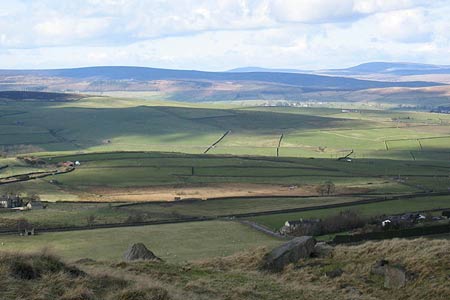
Continue left up the lane to North End farm. Go through the yard in front of the house to a gate before climbing through a small enclosure to a stile. Don't cross the stile, but instead turn left and follow the wall across two fields to arrive at Lightbank Lane (GR062467). Go left along the lane for 350m to a stile in the right hand wall where a track can be seen climbing on to the moor. You'll be relieved to know that this is the final climb on the walk of any significance! On reaching the top at Nab End, stop to enjoy the view for a few moments. A 180 degree panorama opens up over Airedale round towards Skipton and into Wharfedale with Barden Fell and Simons Seat prominent.
From here, the route follows the northern edge of Rombalds and Ilkley Moor to the finish and offers extensive views over Addingham and Ilkley and towards the Southern Dales. Follow the wall on your right, going through a wall stile after 800m to gently climb towards a seat at the viewpoint at Windgate Nick. Keep straight on along the path as it follows the edge above Wharfedale, passing the ancient swastika stone (GR096469) to arrive after 4km at a road on the edge of Ilkley.
Go down the road for 250m, continuing on to a footpath opposite at the first road junction. The path crosses two more roads as it descends into the town to arrive at the top of Parish Ghyll Road. Continue descending to the bottom of the road and turn right into The Grove, Ilkley's main street from where both the bus and railway stations are just 300m away.
The availability of frequent bus and train services from Leeds, Bradford and other centres to both the start and finish points makes this walk very accessible for those without their own transport. In addition, bus 762 links the start and finish every thirty minutes (hourly on Sunday). Full details can be found at the Metro website www.wymetro.com.
Other walks nearby
| Walk 3079 | Silsden Reservoir circular | easy | 6.0 miles |
| Walk 3430 | Farnhill Moor from Kildwick | easy/mod | 4.5 miles |
| Walk 2904 | Cross Hills to Skipton via Low Bradley | easy/mod | 6.5 miles |
| Walk 2942 | Below Silsden Moor | easy/mod | 6.8 miles |
| Walk 2657 | Bradleys Both, near Skipton | easy/mod | 5.5 miles |
| Walk 1793 | Lothersdale | easy/mod | 6.0 miles |
| Walk 2661 | Keighley Moor Reservoir & Hitching Stone from Cowling | moderate | 9.5 miles |
| Walk 1905 | Beamsley Beacon and Bolton Abbey | moderate | 10.0 miles |
| Walk 1135 | Top Withins and the Bronte Bridge | moderate | 8.0 miles |
| Walk 2861 | Pinhaw Beacon from Lothersdale | easy | 4.0 miles |
Recommended Books & eBooks
No suggestions for this area.Messaging & Social Media
Message Walking Britain and follow the latest news.

Mountain Weather
Stay safe on the mountains with detailed weather forecasts - for iOS devices or for Android devices.