Conistone to Grassington via the Dib
Yorkshire Dales Walk
Nat Park - Yorkshire Dales - Upper Wharfedale
County/Area - North Yorkshire
Author - Allan Friswell
Length - 5.0 miles / 8.1 km Ascent - 700 feet / 212 metres
Time - 3 hours 10 minutes Grade - easy
Maps 

| Ordnance Survey Explorer OL2 | Sheet Map | 1:25k | BUY |
| Anquet OS Explorer OL2 | Digital Map | 1:25k | BUY |
| Ordnance Survey Landranger 98 | Sheet Map | 1:50k | BUY |
| Anquet OS Landranger 98 | Digital Map | 1:50k | BUY |
Walk Route Description
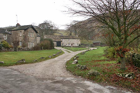
Click image to visit gallery of 9 images.
Leaving the Grassington - Kettlewell Road just before the unmistakeable bulk of Kilnsey Crag, you arrive at the bridge over the Wharfe. Given that to venture into Conistone to park will either meet with justified local complaints about private parking space being taken, or witness your fruitless attempts to put your vehicle between the boulders placed to prevent any outsider parking at all, you should cut your losses and park on the down-side of the bridge, at either end (Grid ref. SD978675).
To start this Yorkshire Dales walk, walk from the bridge into the village. At the square (actually a triangle) with its maypole, follow the left hand lane to a gate, and then continue uphill. The track becomes extremely stony, a more angular version of Brighton Beach. Watch your ankles. The path (now the Dib) narrows and you find yourself walking through a high-sided limestone gorge, even through a squeeze of only a couple of feet. Suddenly you arrive at an open area, where the gully spreads wide, and the sides are covered with vast spills of limestone rocks that are most dramatic.
The path is easy to follow. When you arrive at the second gate (Grid ref. SD 990 679) follow the signed path to Grassington, going uphill to another gully. You are on the Dales Way. Over the step stile at grid ref. SD993677 and then simply follow the broad green track straight ahead. After crossing another stile you pass a lime kiln (Grid ref. SD994672) with a metal plate explaining its history and use.
Another step stile and a gate are followed by a stile in memory of Ray Parish. Here the path splits - you should take the left hand fork. At grid ref. SD998653 the path splits once again - this time follow the right hand fork. Very soon Grassington becomes clear ahead of you, as do, on their ridge, the monuments of Cracoe and, further away, Rylstone. At the very clear crossroads of paths, with a stile and signpost 25 yards ahead of you, you should ignore them and instead cut back sharply right, slightly uphill, making for Bastow Wood on the left, and passing several outstanding examples of limestone pavement. Keep that left hand wall in sight for the next 1/3 mile, otherwise you will miss the very important stile! (Ahead of you come into view the deep sloping terraces where once there were settlements and their cultivation plots).
At grid ref. SD992660 cross the ladder stile and turn sharp right. The path soon forks. If you take the left hand track you will find your descent is almost sheer to the beck below. The right hand path is shallower - I advise it! It descends to a wall, which you negotiate through a gap, and then plunges down, swinging left as it descends the gully and then rising to the gated gap in the wall, with accompanying signposts (Grid ref. SD991662). Take the path to the left, following the wall. You soon find yourself walking along the top of the deep gorge of Dib Beck, full of deciduous trees and the most spectacularly lovely sight in autumn. At a sturdy waymarker the path turns right, uphill, from where you follow your nose, keeping the wall on your left.
At grid ref. SD988664 the wall ends and you go through the gate to follow the clear green way slightly uphill, with the great limestone cliffs on which once stood settlements and fields overlooking you from your right. The next gate exhorts you to "Please shut and fasten". Do so! The track is now gently descending, following the left hand wall, and Kilnsey Crag gradually shows ahead. Go through two gates. The track is now clearly used by vehicles. At its end, a final gate leads you into the back end of Conistone. Turn right along the lane, and follow it as it swings left at the triangle, and so back to the bridge.
Other walks nearby
| Walk 2332 | Mastilles Lane & Bordley from Kilnsey | easy/mod | 6.8 miles |
| Walk 1145 | Grassington, Mastilles Lane & Conistone Dib | moderate | 11.3 miles |
| Walk 1645 | Grassington, Mastilles Lane & Conistone Dib | moderate | 12.0 miles |
| Walk 1846 | Garnshaw House & Linton Falls from Grassington | easy | 3.0 miles |
| Walk 1250 | Great Whernside | moderate | 8.0 miles |
| Walk 1277 | Starbotton & Kettlewell circular | easy/mod | 5.0 miles |
| Walk 1294 | Arncliffe & Kettlewell Circular | moderate | 7.0 miles |
| Walk 1632 | Arncliffe & Starbotton from Kettlewell | moderate | 7.0 miles |
| Walk 1292 | Linton & Thorpe Fell & Cracoe | moderate | 9.0 miles |
| Walk 1407 | Thorpe & Burnsall from Linton | easy/mod | 6.2 miles |
Recommended Books & eBooks
Walking in the Yorkshire Dales: North and East
 This guidebook contains 43 circular day walks in the north and east Yorkshire Dales. It explores the dales, hills and moors between Kirkby Stephen and Pateley Bridge. Walking ranges from gentle 3 mile strolls to more strenuous day-long rambles across the Howgills, Wensleydale, Swaledale, Nidderdale, Mallerstang and Coverdale.
More information
Trail and Fell Running in the Yorkshire Dales
 Guidebook to 40 of the best trail and fell runs in the Yorkshire Dales National Park. Ranging from 5 to 24 miles, the graded runs start from bases such as Ribblehead, Dent, Sedbergh, Malham and Grassington and take in the region's diverse delights, from castles and waterfalls to iconic mountains such as Whernside, Ingleborough and Pen Y Ghent.
More information
Messaging & Social Media
Message Walking Britain and follow the latest news.

Mountain Weather
Stay safe on the mountains with detailed weather forecasts - for iOS devices or for Android devices.