Hadrian's Wall - Cawfields to Steel Rigg
Northumberland Walk
Nat Park - Northumberland
County/Area - Northumberland County
Author - Lou Johnson
Length - 3.5 miles / 5.7 km Ascent - 650 feet / 197 metres
Time - 2 hours 20 minutes Grade - easy/mod
Maps 

| Ordnance Survey Explorer OL43 | Sheet Map | 1:25k | BUY |
| Anquet OS Explorer OL43 | Digital Map | 1:25k | BUY |
| Ordnance Survey Landranger 86 | Sheet Map | 1:50k | BUY |
| Anquet OS Landranger 86 | Digital Map | 1:50k | BUY |
| Ordnance Survey Landranger 87 | Sheet Map | 1:50k | BUY |
| Anquet OS Landranger 87 | Digital Map | 1:50k | BUY |
Walk Route Description
Click image to see photo description.
Hadrian's Wall runs for 73 miles across northern England and its route is followed by a Hadrian's Wall National Trail. In addition on this section of the Wall, the Pennine Way also takes the same route. Construction of the Wall started in AD 122 and it remained in use until the Romans departed in the 5th century. Today there is still significant evidence of the Roman's endeavours with some sections of the wall restored or rebuilt.
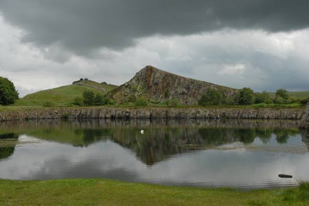
The start for this walk is the Northumberland National Park Centre at Once Brewed (Grid ref NY752668) where pay and display parking is available. From here take the AD122 Bus Service to the Milecastle Inn. After alighting walk north down the minor road opposite the bus stop to the car park at Cawfields (Grid ref. NY712665). Ignore the footpath across fields signed on your right and continue down towards the car park. Approaching the entrance to the parking area bear left and begin to follow the wall. This is a well preserved section and gives an excellent impression of what the Wall would have looked like in its operational days, when it provided an intimidating line of defence.
Looking ahead, you will see the wall follows the undulating country so do not expect level walking. Milecastle 42 is soon reached. This was one of the smaller fortifications placed every Roman Mile. This one is also well preserved and would have been home to a small garrison of men who defended the wall in this area. Continuing on the main path follow the wall as it crosses the top of Cawfield Crags to reach Caw Gap. Ahead more rolling countryside provides some excellent views on both sides as the path follows the contours.
There is less evidence of the Wall now as you pass Milecastle 41 to reach the trig point on the summit of Windshields Crags (345 metres above sea level). Cross the lane (Grid ref. NY750675) and continue along the line of the wall for approximately 250 metres to reach a fine viewpoint (Grid ref. NY752675). From here descend to the road using the permitted footpath. Walk south towards the main road soon reaching the start the car park at the Northumberland Visitor Centre at Once Brewed.
Other walks nearby
| Walk 1198 | Hadrian's Wall & Steel Rigg | moderate | 8.0 miles |
| Walk 2337 | Greenlee Lough and Steel Rigg | easy/mod | 7.5 miles |
| Walk 1677 | Peel Crags & Winshield Crags from Vindolanda | easy/mod | 7.8 miles |
| Walk 2671 | Hotbank Crags & Housesteads from Vindolanda | easy | 5.3 miles |
| Walk 3331 | Cragend & Crow Crags from Housesteads | easy/mod | 8.4 miles |
| Walk 3343 | Hadrian's Wall, Walltown Crags & Aesica | easy/mod | 5.0 miles |
| Walk 2803 | Hadrian's Wall and Haughton Common | hard | 20.0 miles |
| Walk 1786 | Hadrian's Wall & Simonburn circular | easy/mod | 6.8 miles |
| Walk 1987 | Allendale Town Circular | easy/mod | 6.6 miles |
| Walk 1477 | Bellingham to Kiln Rigg by Pennine Way Circular | moderate | 14.3 miles |
Recommended Books & eBooks
The Pennine Way
 Guidebook to the Pennine Way National Trail with OS map booklet. The 265 mile route from Edale to Kirk Yetholm takes three weeks to walk and is suitable for fit and experienced long distance walkers. The route crosses the Peak District, Yorkshire Dales and North Pennines National Parks. Includes separate OS 1:25,000 map booklet of the route.
More information
Walking in Northumberland
 This guidebook contains detailed route descriptions for 36 day walks in Northumberland including the Cheviot Hills. The terrain varies from wild walks and craggy ascents to gentle riverside strolls. Each route ranges from 4 to 16 miles in length and there is the opportunity to link several walks together to create longer treks.
More information
Messaging & Social Media
Message Walking Britain and follow the latest news.

Mountain Weather
Stay safe on the mountains with detailed weather forecasts - for iOS devices or for Android devices.