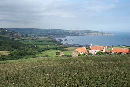
Robin Hood's Bay from Ravenscar
North York Moors Walk
Nat Park - North York Moors - North York Moors East
County/Area - North Yorkshire
Author - Lou Johnson
Length - 8.5 miles / 13.8 km Ascent - 1300 feet / 394 metres
Time - 5 hours 30 minutes Grade - moderate
Maps 

| Ordnance Survey Explorer OL27 | Sheet Map | 1:25k | BUY |
| Anquet OS Explorer OL27 | Digital Map | 1:25k | BUY |
| Ordnance Survey Landranger 94 | Sheet Map | 1:50k | BUY |
| Anquet OS Landranger 94 | Digital Map | 1:50k | BUY |
Walk Route Description
Click image to visit gallery of 6 images.
This dramatic and attractive section of the Yorkshire Coast has attracted visitors for many years even before the North York Moors National Park was inaugurated. The walk's outward route follows a section of the Cleveland Way National Trail with the return over the disused railway that once ran from Whitby to Scarborough. Nowhere is the route particularly tough but there are some ups and downs on the coastal section and the return along the railway is a steady climb. One of the delights of this walk is that it avoids the problems with parking in Robin Hood's Bay. In addition you can arrange the walk so that you arrive in Robin Hood's Bay at lunch time. It is also worth noting that the outward walk to Robin Hood's Bay takes less time than the return.
The start of this North York Moors is roadside parking in Ravenscar (Grid ref. NZ979015) close by the Public Toilets and the National Trust Information Centre. After parking you immediately get an idea of the walk ahead, with most of the route visible from the start. Walk along the road towards the National Trust Centre. Turn left along the signed Cleveland Way. This follows the abandoned railway for a short way before a fingerpost indicates the Cleveland Way leaves the old railway and begins to descend right. Waymarking is first class and there are no problems finding your way. Descending to the left of the golf course the path passes the remains of the old Alum Works also on your right.
Keeping to the cliff top, good progress is made on the next level section. Reaching a track at Stoupe Brow the path descends and crosses Stoupe Beck before climbing up and following the cliff top once more. A steep stepped path into and out of the valley at Boggle Hole (Grid ref NZ954040) leads once more to a level section, which takes you all the way to the slipway at Robin Hood's Bay. Do be careful on the beach here as the tide comes in very fast and the sea cuts off access to the main slipway. The village of Robin Hood's Bay is worth exploring. The main streets have all the usual seaside commerce but away from this there are some interesting narrow lanes that provide a better idea of what the village looked like before commercialisation.
Having explored the village, climb up the main street and turn left into Thorpe Lane. Continue along this road for approximately 400 metres. Reaching the old railway (Grid ref. NZ946052), turn left and follow this multi-purpose cycleway, footpath and bridleway south towards Ravenscar. No further instructions are necessary as the way ahead is clear and not in doubt. Generally there is a steady climb towards Ravenscar and, if you are in the mood, you can get some valuable aerobic exercise if you lift the pace. The first section is rather enclosed at times but the views improve once past the former site of Fyling station with excellent views across almost the whole of the coastal section of the walk.
Other walks nearby
| Walk 1744 | Hayburn Wyke & Ravenscar along the Cleveland Way | moderate | 8.5 miles |
| Walk 1623 | Burn Howe Rigg from Jugger Howes | moderate | 10.0 miles |
| Walk 2130 | Robin Hood's Bay & Hawkser from Fylingthorpe | moderate | 10.0 miles |
| Walk 1395 | Broxa & Broxa Forest | easy/mod | 8.3 miles |
| Walk 1743 | Sneaton Thorpe & Littlebeck from May Beck | moderate | 8.9 miles |
| Walk 2583 | Iburndale and the Esk Valley from Stainsacre | moderate | 10.3 miles |
| Walk 1564 | Hayburn Wyke from Scalby | moderate | 10.2 miles |
| Walk 1464 | Sleights Moor | easy/mod | 7.8 miles |
| Walk 1922 | Goathland & Howl Moors | moderate | 11.2 miles |
| Walk 1758 | Newton House Plantation & Stony Leas | moderate | 10.3 miles |
Recommended Books & eBooks
The Cleveland Way Map Booklet
 Map booklet of the Cleveland Way National Trail, a 177km (110 mile) walk around the North York Moors National Park. This booklet is included with the Cicerone guidebook to the Cleveland Way and the Yorkshire Wolds Way, and shows the full route of the Cleveland Way on Ordnance Survey 1:25,000 maps.
More information
Trail and Fell Running in the Yorkshire Dales
 Guidebook to 40 of the best trail and fell runs in the Yorkshire Dales National Park. Ranging from 5 to 24 miles, the graded runs start from bases such as Ribblehead, Dent, Sedbergh, Malham and Grassington and take in the region's diverse delights, from castles and waterfalls to iconic mountains such as Whernside, Ingleborough and Pen Y Ghent.
More information
Messaging & Social Media
Message Walking Britain and follow the latest news.

Mountain Weather
Stay safe on the mountains with detailed weather forecasts - for iOS devices or for Android devices.