Penzance to Porthcurno via Mousehole and Lamorna
Cornwall AONB Walk
Region - Cornwall AONB
County/Area - Cornwall
Author - Paul Deane
Length - 11.0 miles / 17.9 km Ascent - 2100 feet / 636 metres
Time - 7 hours 40 minutes Grade - moderate
Maps 

| Ordnance Survey Explorer 102 | Sheet Map | 1:25k | BUY |
| Anquet OS Explorer 102 | Digital Map | 1:25k | BUY |
| Ordnance Survey Landranger 203 | Sheet Map | 1:50k | BUY |
| Anquet OS Landranger 203 | Digital Map | 1:50k | BUY |
Walk Route Description
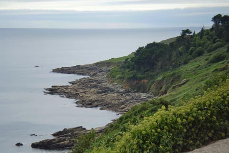
Click image to visit gallery of 4 images.
This Cornwall walk from Penzance to Porthcurno offers a good impression of the section of the South West Coast Path (SWCP) that runs from Penzance around the north coast of Cornwall to St.Ives. Starting in the relatively flat and exceedingly picturesque towns of Penznace, Newlyn and Mousehole, the route enters more rugged countryside with the stunning sea views that make coast path walking such a superb experience. This route finishes in Porthcurno which, in my opinion, at high water on a sunny day, is one of the most beautiful spots in the country.
Start at the car park outside Penzance railway and bus stations (Grid ref. SW476304) and walk southwards past the harbour and, on the road, over the bridge to the boatyards and docks. Follow the road past the lido and join the promenade along the sea front for a mile or so to Newlyn. Rejoin the road as it passes Newlyn Harbour and the powerfully fragrant fish market. Continue along the road as it leaves Newlyn in a south-east direction.
The waymarked path leaves the road and turns left to follow a concrete causeway that skirts the sea. Unfortunately this causeway has been washed away by the sea near Penlee Point leaving you to scramble up a very steep bank to rejoin the road. I suspect this would be nearly impossible if the bank was wet and slippery so, if in doubt, keep to the road from Newlyn to Penlee Point.
At Penlee point it is worth pausing for a while at the memorial to the crew of the Penlee lifeboat 'Solomon Browne' which commemorates the incredible bravery of those men. From Penlee point descend into Mousehole, skirt the harbour and climb out again through the quaintly pretty back streets. Leaving the road at grid ref. SW467256, the route finally enters the countryside at the same time becoming more arduous. Some easy scrambling is required as you traverse the steep foreshore to the gorgeous Lamorna Cove. A look at the storm-damaged quay gives a good impression of the power of the sea.
Leaving Lamorna the path becomes more rugged still with lots of rocky sections. As you pass the Tater-du lighthouse the path joins its service track for a while before dropping down Cough Zawn, back up Boskenna Cliff and across the rocky beach at St. Loy's Cove. Leaving the beach the path climbs through some woodland. This small patch of trees seems to emphasise the almost complete lack of them elsewhere on this section. Next there's a flat (ish) stage for almost half a mile before a steep drop into, and a steep climb out of, Porthguarnon.The route then skirts Le Scath Cove and drops steeply into Penberth, ascends over Cribba Head before descending into Porthcurno and the finish.
There is a good bus service linking Penzance with Porthcurno. Enquire locally for details. The same route also continues west towards Land's End and St.Just.
Other walks nearby
| Walk 2207 | Penzance - a town stroll | easy | 1.5 miles |
| Walk 2205 | Newlyn - a village trail | easy | 1.0 miles |
| Walk 2208 | Marazion - a town stroll | easy | 1.0 miles |
| Walk 1224 | Men-an-tol & Ding Dong Mine | easy | 3.0 miles |
| Walk 2354 | Merry Maidens & Lamorna Cove | easy | 4.1 miles |
| Walk 2614 | St Loy's Cove & Logan Rock | moderate | 8.5 miles |
| Walk 1081 | Zennor & St Ives coast path | mod/hard | 11.0 miles |
| Walk 1223 | Morvah to Zennor coast | moderate | 5.5 miles |
| Walk 3325 | Chun Quoit & Carn Kenidjack | easy | 4.0 miles |
| Walk 1028 | Chun Quoit and Botallack | moderate | 8.0 miles |
Recommended Books & eBooks
The South West Coast Path
 Guidebook to walking the entire South West Coast Path National Trail. The route runs for 630 miles from Minehead to Poole along the north Devon, Cornish, south Devon and Dorset coastline. Divided into 45 stages, this long-distance coastal trek could be completed within 4 weeks, or walked in sections. Guide includes maps and essential information.
More information
South West Coast Path Map Booklet - Minehead to St Ives
 Map of the northern section of the 630 mile (1014km) South West Coast Path National Trail. Covers the trail from Minehead to St Ives along the north Devon and Cornish coastline. This convenient and compact booklet of Ordnance Survey 1:25,000 maps shows the route, providing all of the mapping you need to walk the trail in either direction.
More information
Messaging & Social Media
Message Walking Britain and follow the latest news.

Mountain Weather
Stay safe on the mountains with detailed weather forecasts - for iOS devices or for Android devices.