Clapham, Oxenber Woods, Feizor & Settle
Yorkshire Dales Walk
Nat Park - Yorkshire Dales - Three Peaks Country
County/Area - North Yorkshire
Author - Peter Schofield
Length - 7.5 miles / 12.2 km Ascent - 1150 feet / 348 metres
Time - 4 hours 50 minutes Grade - easy/mod
Maps 

| Ordnance Survey Explorer OL2 | Sheet Map | 1:25k | BUY |
| Anquet OS Explorer OL2 | Digital Map | 1:25k | BUY |
| Ordnance Survey Landranger 98 | Sheet Map | 1:50k | BUY |
| Anquet OS Landranger 98 | Digital Map | 1:50k | BUY |
Walk Route Description
Click image to visit gallery of 7 images.
The South Western edge of the Yorkshire Dales National Park north of the A65 offers some attractive if undemanding walks and this one, which mainly follows dry grassy paths, can be comfortably completed in half a day. The route passes through varied scenery of ancient woodland, a couple of attractive villages and includes fine views of both Ingleborough and Pen-y-Ghent. The availability of public transport makes this walk possible for those without a car.
This Yorkshire Dales walk starts from the National Park car park at Clapham (grid ref. SD746692). This charming Dales village is itself worthy of exploration and James Faraday, father of the scientist Michael Faraday was once the village blacksmith. From the car park, follow the path along its southern edge through a farmyard. It then continues as a clear path passing through grassy pasture and over a number of stiles before descending to the village of Austwick. Turn left and continue along the street for 250m before turning right in the village centre on to the road towards Settle.
The road leaves the village to cross Austwick Beck after 300m as views open out to the left up the valley towards the crags of Moughton. Immediately after the bridge, bear left on to a bridleway and continue for 500m to a stile with a finger post indicating a footpath to Feizor (grid ref. SD773682). Cross the stile and follow the path across a grassy meadow as it climbs gently to reach the access road to Wood House at a stile, while behind you Austwick is cradled by the limestone cliffs of Norber.
Cross over the road and continue up the easy climb to cross another stile. The path can be seen continuing ahead across the pastures but our route bears left towards a gap in the wall from where a concessionary path climbs steeply through Oxenber Wood. This ancient woodland is a Site of Special Scientific Interest and its sunny slopes are a veritable carpet of wildflowers during spring and summer. Please note the gpx file does not include the diversion through Oxenber Woods and continues on the direct path to Feizor.
Follow the red way markers as the path climbs through the wood before levelling out to meet another path (indicated by orange way markers) after 600m. Go right on to this path as it winds through the woodland past a limestone pavement typical of the area. After 200m the path briefly emerges from the trees and your efforts are rewarded with a fine view towards the hamlet of Wharfe while in the background, the mighty Ingleborough serenely presides over the scene.
The way marked path continues through the woodland to arrive at a gate on to the track at Feizor Nick (grid ref. SD789684). From here, there's a fine view of another of the Three Peaks as a panorama opens out across Ribblesdale towards Pen-y-Ghent. Turn right on to the track as it first gently climbs and then descends to the pretty hamlet of Feizor.
Continue through the village for 200m to reach the village notice board from where a finger post indicates a path to the left to Stackhouse. Follow this path to another finger post after 600m and take the left hand route towards Stackhouse. After a further 1.5K, you arrive at a path junction (grid ref. SD804664) where the route goes right through a wall gap to gently descend towards Stackhouse as Pen-y-Ghent is once again seen to the left and views open out ahead towards Attermire Scar.
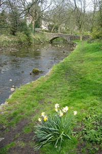
As the path descends more steeply, take the leftmost of two adjacent stiles towards a finger post on the track visible below. Turn right along the track to Stainforth Lane (grid ref. SD813653) and go right along the lane for 200m to a gate on the left where a clear path can be seen crossing the field. This is the Ribble Way which is followed to the end of the walk at Settle Bridge. Turn left over the bridge from where it is a short walk back to the Market Place.
The start and finishing points of the walk are linked by bus 581 which operates up to eight times daily on weekdays only. If you are travelling from the south via Skipton, an alternative is to take the train to Clapham and return from Settle, which has the advantage of running daily including Sundays. However, the walk down the quiet lane from Clapham station to the start will add 2K to the total distance. Details of both train and bus times can be found on the Dalesbus website www.dalesbus.org
Other walks nearby
| Walk 1251 | The Norber Erratics & Sulber Gate | moderate | 8.0 miles |
| Walk 2620 | Sulber Gate & Crummack Dale from Austwick | moderate | 9.5 miles |
| Walk 3091 | Ingleton Waterfalls Walk | easy | 4.3 miles |
| Walk 1121 | Pen-y-ghent & Plover Hill | moderate | 9.0 miles |
| Walk 1013 | Pen-y-ghent | moderate | 6.5 miles |
| Walk 1500 | Pen-y-ghent via Horton Scar | moderate | 6.8 miles |
| Walk 3433 | Yorkshire Three Peaks from Horton-in-Ribblesdale | very hard | 24.5 miles |
| Walk 2649 | Attermire Scar & Malham Tarn from Stainforth | mod/hard | 16.5 miles |
| Walk 2256 | Great Stone of Fourstones | easy/mod | 6.7 miles |
| Walk 1208 | Ingleborough & Park Fell | moderate | 7.5 miles |
Recommended Books & eBooks
Walking in the Yorkshire Dales: North and East
 This guidebook contains 43 circular day walks in the north and east Yorkshire Dales. It explores the dales, hills and moors between Kirkby Stephen and Pateley Bridge. Walking ranges from gentle 3 mile strolls to more strenuous day-long rambles across the Howgills, Wensleydale, Swaledale, Nidderdale, Mallerstang and Coverdale.
More information
Walking in the Yorkshire Dales: South and West
 Part of a two-book set, this guidebook describes 44 walks in the southern and western Yorkshire Dales, including the famous 23 mile Three Peaks circuit over Pen-y-Ghent, Whernside and Ingleborough. The other, mostly circular routes of 3½ to 13 miles cover the scenic region between Sedbergh, Kirkby Lonsdale, Settle, Skipton and Grassington.
More information
Messaging & Social Media
Message Walking Britain and follow the latest news.

Mountain Weather
Stay safe on the mountains with detailed weather forecasts - for iOS devices or for Android devices.