Walk 1002 - printer friendly version
The Fairfield Horseshoe Walk
Author - Lou Johnson
Length - 11.0 miles / 17.9 km
Ascent - 3400 feet / 1030 metres
Grade - mod/hard
Start - OS grid reference NY375045
Lat 54.432061 + Long -2.964976
Postcode LA22 9AD (approx. location only)
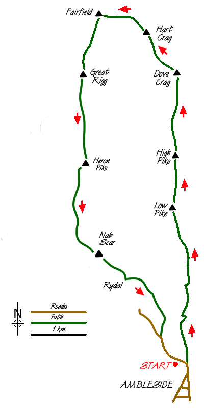
The Fairfield horseshoe is a popular Lake District walk starting and finishing in Ambleside (Grid ref. NY 375045). A shorter version is detailed in walk 1170. From the centre of Ambleside take the Kirkstone Road for a short way turning down the first lane on the left. This leads to Low Sweden Bridge from where the views of the Fells begin to improve. The onward path to Low Pike is well-trodden and you soon find yourself alongside the ridge wall. This leads onwards over High Pike and onto Dove Crag. As you climb, the views on both sides are excellent and improve with each step.
Although you are now in the high fells, progress is easy. Although you are climbing most of the time there is nothing too strenuous and you feel as though you are covering a lot of ground. By the time you reach Dove Crag, you have earned a rest, and this is an excellent place to see the majority of the Fairfield horseshoe. Suitably refreshed head on to Hart Crag where the view north opens out with St Sunday Crag dominating the view. The ascent is nearly over and after dropping off the northern side of Hart Crag to Link Hause a steep rocky upward pull brings you onto Fairfield.
As the name suggests, this mountain is a grassy plateau. However on its north eastern flanks there are some superb crags and rather than follow the main path it is better to keep to your right following the narrow trod which skirts around the top of the cliffs. Besides an excellent view into Deepdale, you are able to appreciate the full extent of Fairfield's rocky aspect. Suitably impressed, you should arrive at the summit cairn from where the far ranging views are excellent. However because of the domed nature of the plateau it is better to explore a little with a short walk north to inspect Cofa Pike and Grisedale Hause particularly rewarding.
Having reached the highest point of the walk it is downhill almost all the way back to Grasmere. In poor visibility do be careful to take the correct path off Fairfield as it can be a confusing place in low cloud. Keeping on the main path to Great Rigg you will find it easy to keep a good pace with an excellent Lakeland panorama ahead. Reaching the cairn on Great Rigg descend taking the main path to Heron Pike.
From this last major 'top' of the route continue south to Nab Scar from where there is a steep descent into Rydal. Keep to the north side of Rydal Hall and follow the drive through pleasant parkland to meet the main road just outside Ambleside. Turn left along the main road and you will be back at the start.
Messaging & Social Media
Message Walking Britain and follow the latest news.

Mountain Weather
Stay safe on the mountains with detailed weather forecasts - for iOS devices or for Android devices.