Walk 1023 - printer friendly version
Wansfell Pike & Wansfell Walk
Author - Lou Johnson
Length - 7.5 miles / 12.2 km
Ascent - 1800 feet / 545 metres
Grade - easy/mod
Start - OS grid reference NY375045
Lat 54.432061 + Long -2.9649759
Postcode LA22 9BW (approx. location only)
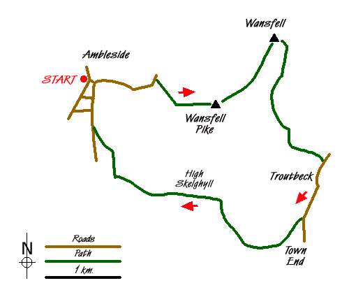
Wansfell overlooks the town of Ambleside and for many years its ascent has proved popular with walkers. The first time I walked this fell the approach path was in a sorry state, very muddy and slippery and eroding fast. Since then significant improvements to the path have been made using rock and the former erosion has all but disappeared. Today Wansfell makes an excellent Lake District circular walk which provides some fine views of Lakeland scenery.
The walk starts in Ambleside (grid ref. NY375045) where parking can be a headache at busy times of the year. The walk starts near the Salutation Hotel in the centre and you have a choice of initial routes. You can either follow Stockghyll Lane uphill or alternatively follow the footpath that runs alongside the ghyll towards Stockghyll Force waterfall exiting onto the lane where the footpath ends. Whichever way you start you end up on Stockghyll Lane which sees very little traffic especially as you climb away from the houses. At grid ref. NY385045 take the signed footpath on your right that leads across fields towards Wansfell. The path is good and progress fast with improving views towards the Langdales and Fairfield in particular.
As the summit nears, the path passes through a rocky patch and soon leads to the highest point (482m.) at this end of the fell from where the views are mainly to the west. To reach the highest elevation on Wansfell ignore the main path dropping down to Troutbeck and head northeast alongside the ridge wall to the highest point (487m.) which is marked by a cairn. Despite the gain in height the view is less interesting although you can claim to have visited the real summit - a feat achieved by only a few of the walkers who sent out to ascend Wansfell.
To continue follow the developing path southeast. This path roughly follows a wall but then takes a shortcut to shadow another wall heading roughly SSW. After a short wall the path has developed enough and becomes easy to follow. The path leads into a walled lane - Nanny Lane (grid ref. NY403045), which is followed all the way down to a lane in Troutbeck. Turn right along the lane and walk through the village as far as the Post Office, the only source of refreshments on the walk but with limited opening times.
Just past the Post Office, the lane forks. Take the right hand lane (Robin Lane) which immediately starts to climb. The lane soon becomes a track and you swing in a large loop around the fellside to reach a junction of tracks (grid ref NY397023). Bear half left here following the signs for Ambleside dropping down to cross a stream before climbing once more to join the access road to High Skelghyll Farm.
Continue past the farm. The track soon enters delightful Skelghyll Wood. Continue following the main track ignoring tracks to the left as these drop down in to the valley too soon and leave you with an unpleasant walk along the main A591. The main track leaves the wood and you can see Ambleside ahead.
Messaging & Social Media
Message Walking Britain and follow the latest news.

Mountain Weather
Stay safe on the mountains with detailed weather forecasts - for iOS devices or for Android devices.