Walk 1027 - printer friendly version
Nare Head & Portloe Walk
Author -
Length - 7.0 miles / 11.4 km
Ascent - 1450 feet / 439 metres
Grade - moderate
Start - OS grid reference SW916395
Lat 50.218712 + Long -4.9226549
Postcode TR2 5QB (approx. location only)
This Cornwall walk combines some fine Cornish countryside, with an interesting village and a section of the South West Coast Path. The outward leg along the coastal path has plenty of ups and downs and is not for those wanting a gentle stroll beside the sea. The views of the coastline are superb and conclude with a visit to the small harbour and village at Portloe. The return leg is across fields and along typical Cornish lanes with the opportunity to explore Veryan and its well-known round houses that guard entry to the village.
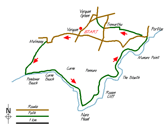
The start is in the centre of Veryan where limited parking is available near the Village Hall (Grid ref. SW 916395). Locate the New Inn and follow the St Mawes road out of the village going past the cricket ground on your left. The road narrows and descends steeply to reach Melinsey Mill. At the sharp bend turn left along the footpath to Pendower Beach. This path climbs up the side of the valley before descending again to cross a bridge. Continue through the grounds of Lower Mill following the footpath on the eastern side of the stream to reach Pendower Beach. If the tide permits turn left along the beach or else use the access road and high level path to reach Carne Beach. Leave the sands at the main access point for Carne Beach to reach the lane. Turn left along this for a short way before turning right up steps to a gate leading to the cliff path. You are now on the South West Coast Path and you stay with this for the remaining coastal section through to Portloe.
As with all coastal walking expect plenty of ascent and descent and allow longer than you might expect to complete the walk. Reaching Nare Head you have reached the highest point of the walk and you can enjoy the excellent views in both directions. Continue eastwards past Rosen Cliff to descend to Kiberick Cove. To regain the cliff top the path climbs in zigzags to reach a white house at the top. Here the path passes through a small pine plantation before descending to Portloe.
The small harbour is picturesque and the village boasts a pub, hotel and cafe making it a pleasant place to take a break. To continue head west uphill passing the Ship Inn on your right. Locating the footpath on the right to Trewartha is not easy and you need to use your map reading skills to find this one! At the time of writing it went directly in front of "Old White Cottage" past a couple of newer houses to enter a field. Trend right across this field to reach a gate. Keeping the wall on your left to reach a final gate at the top of the field. This leads onto a farm track that leads to Trewartha.
Turn left at the lane at the top and then immediately right past the Methodist church. Look out for a signed footpath on your right and take this across meadows to reach the road in Veryan Green. Turn left back to the starting point.
Note - There are six roundhouses in Veryan. Two located on the eastern edge of Veryan Green, two on the road to Portloe via Camels and two on the lane to Gwendra.
Messaging & Social Media
Message Walking Britain and follow the latest news.

Mountain Weather
Stay safe on the mountains with detailed weather forecasts - for iOS devices or for Android devices.