Walk 1031 - printer friendly version
Polruan & Lanteglos Church Walk
Author - Lou Johnson
Length - 4.3 miles / 6.9 km
Ascent - 900 feet / 273 metres
Grade - easy/mod
Start - OS grid reference SX149513
Lat 50.332479 + Long -4.602196
Postcode PL23 1NP (approx. location only)
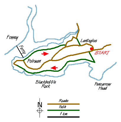
This walk combines coastal, estuary and rural walking in a short but enjoyable route. As an added bonus you visit the village of Polruan, which is situated across the River Fowey from Fowey village. Polruan unlike its opposite cousin has suffered little from commercialisation and retains much of the charm you would expect from a harbour village.
The start is the National Trust car park at Pencarrow (Grid ref. SX 149513). Exit the car park and make for the main road. Turn right along this road for 200 metres and go left over a stile. The path crosses a field heading towards Pencarrow Head. Reaching another stile you can either go straight ahead and enjoy the views from Pencarrow Head or turn right to continue on the main route. Note - should you decide to visit the headland then retrace your steps to this stile.
You are now on the South West Coast Path and like much of its route it switchbacks up and down making it much harder than the map might suggest! To your left, nearly 300 feet below, are Great Lantic Beach and Little Lantic Beach. These can be reached by a steep path, which requires plenty of energy for the climb back to the cliff tops. The coastal path leads on past Blackbottle Rock before joining a road on the southern outskirts of Polruan. Descend into the village to reach the quay where the ferry to Fowey departs.
The village has a few shops, pubs and restaurants and is a pleasant place to spend some time. From the ferry head east along the street running parallel with the shore. A signed footpath leads to "The Hills". At first it is a narrow lane but after climbing some steps on the right it leaves the houses behind and climbs steeply offering fine views of Fowey River to your left.
After entering some pleasant woodland, the path reaches a track. Turn right here for a few yards before picking up the continuation of the footpath on your left. Follow this, keeping to the upper path to reach a road. Turn left with the wall to your right and follow this path as it descends steeply down to the head of a creek to reach the road again. Turn left along the lane to locate a grassy track on your right. This climbs steeply to reach Lanteglos-by-Fowey church. Leave the churchyard and head east along the lane, which climbs gently and soon reaches the starting point of the walk.
Messaging & Social Media
Message Walking Britain and follow the latest news.

Mountain Weather
Stay safe on the mountains with detailed weather forecasts - for iOS devices or for Android devices.