Walk 1048 - printer friendly version
Ardingly Reservoir Walk
Author - Peter Smyly
Length - 8.5 miles / 13.8 km
Ascent - 600 feet / 182 metres
Grade - easy/mod
Start - OS grid reference TQ306302
Lat 51.0563 + Long -0.13790133
Postcode RH17 6JF (approx. location only)
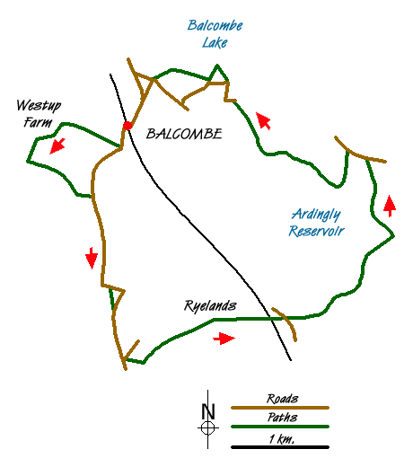
This circular route explores part of rural West Sussex. By leaving the lakes of Ardingly Reservoir and Balcombe Lake until the latter part of the walk, there is a chance to see first a rural landscape to the west of the railway line with fields, woodland, duck ponds, country lanes and farm land. Public footpath signs tend to appear at moments of possible indecision, but a map and compass are advisable in any case. While the route presents no difficulties in terms of terrain or gradients, there are a number of wooden stiles to cross. The route passes through the occasional field with cattle.
The proximity of the countryside to the railway line is indicated by the appearance at the start of the walk of a narrow public footpath down through woods from the station car park at Balcombe. After a brief clearing, the path leads down stone steps and, at the foot of the hill, a public footpath sign appears on the right opposite a house, the route leading up a sloping hillside. At the end of the second field, a road is reached. Turn right and then almost immediately left to follow a narrow tree-lined lane with woodland on the left (Peter's Wood on the map) and a field on the right, past a muddy duck pond, also on the right as the route goes past Westup Farm and then due south to Bury Wood. The track leads briefly through trees.
Take a left turning to follow a waymarked path through more woodland to cross a field and pass another muddy duck pond on the left. Cross the field to the right to meet up with a narrow country lane that leads down to Rowhill Lane. Now follow this narrow country lane due south, past Upper Pilstye with a pretty duck pond with water lilies on the left. Going downhill, the road bends to the left. Take a narrow path on the right across a field to rejoin the road. Follow the road ahead and, after passing a turning for Sidnye Farm on the right, at the next T junction, turn left and then almost immediately right to join up with the Sussex Ouse Valley Way. The route turns off the road and goes through a metal kissing gate just before Great Bentley Farm and, after crossing a wooden footbridge over a stream, the Ouse Valley Viaduct is glimpsed in the distance and the path heads this way across a wheat field, up a hill and then across another field past Ryelands Farm.
After passing under the impressive viaduct and across another field, cross the next road, Bordehill Lane, and follow it to the right where it leads over a bridge. Now take an immediate left turning along the next public footpath. The route now continues alongside a stream on the edge of a field. Looking back, the occasional train may be seen going over the railway viaduct. Although this point of the walk has a remote rural feel about it, it is not far from here to the reservoir which tends to attract numbers of people due to ease of access by road and a sizeable car park nearby. Passing a footbridge with a wooden gate, continue past woodland on the right to reach another footbridge with wooden kissing gates. The route ahead leads to a waymarked trail up through fields with a sign warning of cattle, then after about a quarter of a mile, the reservoir comes into view quite suddenly round a corner, though its proximity may have been anticipated if you heard the sound of car doors shutting and people talking first, indicating the nearby car park.
A complete circuit of the reservoir is not an option. The aquatics centre is on the left and there is no public right of way along the shore on this side of the lake. Instead, walk along the dam as the full extent of the reservoir is revealed. Despite the artificial nature of it, this is quite a pretty lake with its various inlets and it is backed by low hills with trees. The lake was created in 1978 and it lies within the High Weald Area of Outstanding Beauty. It is designated a Local Nature Reserve. Water sports activities include sailing, canoeing and windsurfing, but swimming is strictly not allowed. Follow the path around the eastern shore to reach the causeway. There is no public access to the north from here, but there is one point in particular on the causeway that offers a clear view between trees of the reservoir to the south.
At the far end of the causeway, a path to the left continues to follow the lake in a roughly north-westerly direction and in the autumn this area can be full of ripe blackberries. On emerging on to Mill Lane, follow it round to the left then right. When it bends left again, a narrow path leads off through woodland and in around half a mile, Balcombe Lake comes into view. There are various ways of returning to the railway station from Balcombe Lake. One is to follow the narrow lane straight ahead uphill from the dam as far as Mill Lane then follow public footpath signs across a field to the right and through woods to the cricket field and then on to Balcombe Hill where there is a village store. Go straight ahead at the crossroads where there is a sign for the railway station which is now just a few minutes walk away.
Messaging & Social Media
Message Walking Britain and follow the latest news.

Mountain Weather
Stay safe on the mountains with detailed weather forecasts - for iOS devices or for Android devices.