Walk 1076 - printer friendly version
Dizzard Point & Crackington Haven Walk
Author - Lou Johnson
Length - 8.0 miles / 13 km
Ascent - 1500 feet / 455 metres
Grade - moderate
Start - OS grid reference SX176993
Lat 50.764546 + Long -4.5878139
Postcode EX23 0DQ (approx. location only)
This Cornwall walk explores a section of varied coastline of the county. Although this part of the coast sees few walkers it is one of the finest parts of the South West Coast path in Britain's most westerly county. The summit of the walk is reached quite soon after the start reaching over 500ft above sea level with cliffs plunging down to the sea at Dizzard Point. The return section of the route takes you inland to enjoy the pleasant countryside and a section of fine deciduous woodland.
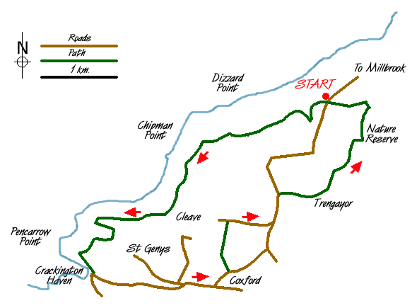
The start is in a lay-by (grid ref. SX 561917) beside the minor road from Dizzard to Millbrook a few miles north of the A39 at Treskinnick Cross. From the lay-by take the signed footpath towards the sea and within a minute or so you are on the South West Coast Path. Turn left (west) and follow the clear path which soon descends into a wooded valley. Cross the bridge and climb steeply along the edge of Bynorth Cliff. The gradient eases and you reach the trig column on Dizzard Point.
From here there is a superb view north across Widemouth Bay to Bude and beyond. Descending the path reaches a stile after which the path goes close to the cliff edge and improved towards Bude. Reaching Chipman Point the path descends steeply and you realise that coastal walking is not as easy as it sounds especially when you can see that all the height lost has to be regained almost immediately. Crossing a stream the climb starts and reaching the top you can see the church tower at St Gennys, which can be visited by taking a short diversion from the main route.
The switchback nature of the coastal path means another steep descent to Cleave followed by an equivalent ascent has to be overcome. However this is a much easier section than the one just completed with the small settlement of Cleave adding interest to the walk. The climbing is not over as the path is far from level on the final approach around Pencarrow Point and down into Crackington Haven. Before turning inland admire the view ahead with the headland of Cambreak guarding the entrance to the Haven.
Reaching the road in Crackington Haven turn left and climb steadily on the road to Wainhouse Corner. At the Methodist church turn left to Coxford. The lane soon descends and near the bottom cross the footbridge on the left and climb northeast to a gate in a wall. With the boundary hedge on your right continue the climb to reach a walled lane. Turn right and continue along this to reach a wider lane at Higher Crannow.
Turn left and continue along this lane for about a quarter of a mile. Turn right for Trengayor and continue through the farmyard and along a track. At the end of the track you will find a waymarked footpath to descend into very attractive woodland. The first section was slightly overgrown but it soon improved. Reaching a stream take the left fork to cross the stream continuing downstream on the west bank. Cross the footbridge on your right and pass behind a house. Follow the drive for a short way before taking the first signed footpath on the left across a field to re-enter the woodland.
You will soon reach a cottage. Just before you reach the cottage cross the footbridge on your left. You now have to locate a narrow footpath that trends west alongside a small stream, which you follow uphill to a gate. Continue uphill in the same direction crossing a stile to reach the start of the walk.
Messaging & Social Media
Message Walking Britain and follow the latest news.

Mountain Weather
Stay safe on the mountains with detailed weather forecasts - for iOS devices or for Android devices.