Walk 1085 - printer friendly version
Upper & Lower Boddington Walk
Author - Millennium Way
Length - 7.0 miles / 11.4 km
Ascent - 150 feet / 45 metres
Grade - easy/mod
Start - OS grid reference SP456500
Lat 52.146413 + Long -1.335022
Postcode OX17 1EW (approx. location only)
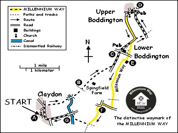
This gentle circular Oxfordshire and Northamptonshire walk starts in the picturesque village of Claydon, and meanders across mostly flat farmland & open countryside, crossing the Oxford Canal at two points and touching the delightful villages of Lower & Upper Boddington. Claydon is Oxfordshire's most northerly village. Local pubs only offer limited opening hours so check with them first if you wish to take refreshment - Carpenters Arms, Lower Boddington and The Plough Inn, Upper Boddington. Why not consider taking a picnic? For part of the walk, you will enjoy the delights of The Millennium Way where you will be guided by the distinctive black waymarkers. You can also start this walk in Upper Boddington opposite The Plough and start at D below.
A - We begin our walk from St James the Great church in the picturesque village of Claydon. With your back to the church (at the East gate) go left down the road, through the village and take footpath on right by road sign hidden in bush, signed to Lower Boddington (opposite the junction with Fenny Compton Road). Go past the wooden bollard & house called The Brambles. Walk down narrow passage with brick wall on right to take stile to field. Go ahead for 60 paces and take fence stile right into field and go left keeping hedge left to stay along edge of field. Go over new single stile then double stile and keep ahead along left field edge to take further stile to next field. Keep ahead with hedge left to corner of field, through two large metal gates, then across canal bridge and ahead down track to go over corner stile to eventually take footbridge over small stream to next field.
B - Go ahead over dismantled railway line and take stile into next field to go 1/4 right across field and take double stile and footbridge just to left of farm buildings by a large lone oak tree. Stay ahead under power lines with hedge and farm buildings right. After 200 yards take gate right, crossing the scrub to take further stile into next field. Go left along edge of field to take stile in top left corner. Go diagonally 1/4 right across centre of field (or around right-hand perimeter if heavily cropped) towards far-right corner, through gate and wooden fenced corridor to take gate to lane (this may be a crossing point for HS2 so please follow any diversions). Turn left and stay along lane to enter Lower Boddington at crossroads with the sometimes closed Carpenters Arms ahead of you.
C - Go ahead over crossroads and with Carpenter's Arms R, walk through Lower Boddington. Continue steeply uphill, ignoring the first bridleway right (opposite The Manor House) and a little further up the hill where the road swings left, take bridleway right to Cleveland Farm. Go up track and at the top, opposite the large barn, take metal gate left to field. Go right with hedge right to field end and exit by gate to road. Go left on tree lined road and after some 1/2 mile come to crossroads.
D - Go left into Upper Boddington. Pass The Plough Inn on left (restricted opening times) and, after 70 paces, take short road left to find T junction (Here you join The Millennium Way and will be guided by our distinctive way markers). At this T junction go left up Church Road to pass post box left and school right and leave Upper Boddington (a slight detour on your left, to visit St. John the Baptist Church, is worthwhile). Continue on undulating lane with panoramic views right and after half a mile road swings right as you enter Lower Boddington. Go past the bridleway left which you took on the outward route then opposite first house on right (Sears Farmhouse) take bridleway left, which becomes a lane and goes down to the road.
E - Cross road and go ahead on track past Cleve House left. After 100 paces, before Paradise Farm, turn right through wooden kissing gate into field. Turn 1/2 left for 100 paces to fence corner of small paddock and bear left to take another wooden kissing gate. Go with fence right to small field corner and take large metal gate left to cross low bridge. You now encounter HS2 works, so follow new timber fenced waymarked pathway across the HS2 route. Exit fenced corridor after a while via waymarked metal gate and go * slightly left across large field to find and take narrow well waymarked mid hedge gap (you may need to cross crops in this field as the path is not obvious and the crops may obscure the waymarked gap so *alternatively go with hedge right to corner of field then turn left in same field keeping hedge & trees right to find the narrow waymarked gap). Go through this gap across old railway line coppice to take another waymarked gap, then go directly across field to reach corner hedge & trees. Keep hedge left to reach far corner of field. Take the large corner gap to road, then turn right.
F - Continue up to road junction then go left, signed Claydon and where the road turns sharp right go left through wide gap then along bridleway. Go ahead across field to take gap and continue with hedge R. Go through small gap ahead and then cross field past two well separated oak trees to mid hedge gap (if this field is heavily cropped with an indistinct path just go left around field edge to reach gap on far side). Take gap and cross field towards next mid hedge gap. (Here we leave The Millennium Way). Do NOT take gap but go right along field edge keeping hedge left. Go through corner gaps of next two fields keeping hedge left and keep a sharp look out for a concealed waymarked footbridge on left just before corner of field. Take footbridge into field continuing 1/2 right across to far corner stile and metal gate by canal bridge.
G - Go over stile to road, then over canal bridge continuing gently up the road for some while to reach a junction. Turn right at the junction, which will bring you back into the peaceful village of Claydon and your starting point near the church.
Please Note: The HS2 rail link will affect some of the footpaths on this circular walk. Signed diversions may be encountered and our advice is to follow these diversions.
Messaging & Social Media
Message Walking Britain and follow the latest news.

Mountain Weather
Stay safe on the mountains with detailed weather forecasts - for iOS devices or for Android devices.