Walk 1096 - printer friendly version
Highbury & Islington & New River Walk
Author - Peter Smyly
Length - 1.5 miles / 2.4 km
Ascent - 50 feet / 15 metres
Grade - easy
Start - OS grid reference TQ315847
Lat 51.545881 + Long -0.10500188
Postcode N5 1RQ (approx. location only)
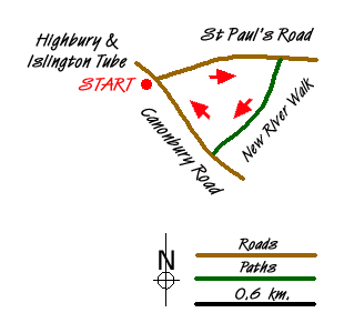
Appearing as a blue line on a London map, New River Walk is located half a mile to the east of Highbury and Islington railway station in north London. Lying to the south of St Paul's Road and it runs in a roughly north-east to south-west direction, ending at Canonbury Road.
In fact, the name is a misnomer. As a sign to one side of the path running alongside the water channel explains, New River is neither new nor a river. It is in fact a man-made channel. The main part of the walk follows a footpath alongside a water channel, a surprisingly scenic stretch set amid a residential part of Islington. The walk can be done in the form of a triangular route, starting from, and finishing back at, Highbury and Islington station, for instance walking along St Paul's Road first. The riverside stretch is a contrast to the two busy main roads that complete the triangle.
Under the right weather and lighting conditions it can be a very pretty place as I hope my photos illustrate. A good time to go is in the autumn on a bright sunny day when the autumnal colours of the trees are starkly apparent. All the more so when you see trees reflected in the still water which appear as if seen in a mirror.
Messaging & Social Media
Message Walking Britain and follow the latest news.

Mountain Weather
Stay safe on the mountains with detailed weather forecasts - for iOS devices or for Android devices.