Walk 1098 - printer friendly version
Howden Edge & Derwent Valley Walk
Author - Lou Johnson
Length - 14.0 miles / 22.8 km
Ascent - 1200 feet / 364 metres
Grade - mod/hard
Start - OS grid reference SK172893
Lat 53.400249 + Long -1.7427794
Postcode S33 0AQ (approx. location only)
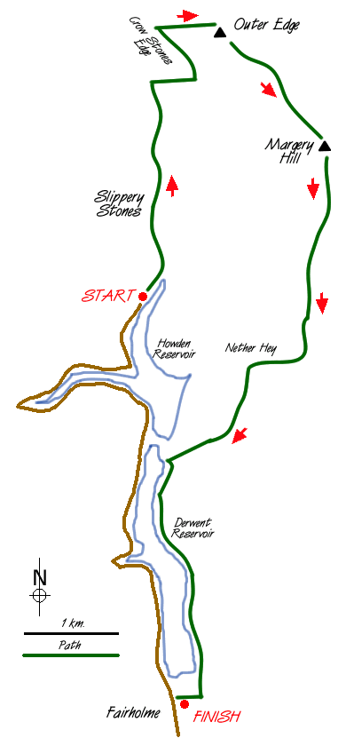
The moors to the east of the Derwent Reservoir provide miles of easy walking with good views. This Peak District walk offers a pleasant excursion with the opportunity to stride out across the wide open moors. However after rain they can be very boggy and we chose to walk the Edge after a heavy overnight frost. Access to the northern section of the Derwent Valley is restricted at weekends throughout the year. There used to be a bus service from Fairholme car park (grid ref. SK 172893) close to the dam which took you to the head of the reservoir to start this walk (grid ref. SK167938).
Leaving the A57 Sheffield to Glossop road head north up the western side of Ladybower Reservoir to the car park (toilets and cafe). With the bus no longer operating you need to walk north along the road for 5 miles to King's Tree where the bus terminated. From here we took the path over Slippery Stones Bridge and followed the River Derwent to Oaken Bank. Here a footpath on the right leads up the hillside in a series of zig-zags to put you on course for Crow Stones Edge, which is an ideal spot for a rest with a good view down the Derwent Valley to the Howden and Derwent Reservoirs.
From the Crow Stones head due east to pick up the path along the top of Outer Edge. There are numerous sheep trods and other small paths to help you cross this wild moorland. It was here that we saw a white hare - common in this area during the winter. On reaching the edge most of the climbing is over and you have a steady level stroll for about three miles with good views across to Bleaklow and the surrounding moors.
Turning south-east along the edge you now cross the potentially boggy area to Howden Edge and Margery Hill. Even after a heavy frost some of the soggy areas were still soft and some care was needed to keep dry feet. Continuing on the edge path you pass High Stones before turning west near Row Top to pick up the track descending across the flanks of Nether Hey to the east shore of the Derwent reservoir. Turn south on the well maintained track alongside the reservoir for the easy amble back to Fairholme car park.
Messaging & Social Media
Message Walking Britain and follow the latest news.

Mountain Weather
Stay safe on the mountains with detailed weather forecasts - for iOS devices or for Android devices.