Walk 1124 - printer friendly version
Beacon Tarn & The Beacon from near Torver Walk
Author - Lou Johnson
Length - 4.0 miles / 6.5 km
Ascent - 800 feet / 242 metres
Grade - easy/mod
Start - OS grid reference SD289910
Lat 54.309626 + Long -3.0942927
Postcode LA12 8DW (approx. location only)
This relatively low fell occupies an isolated position just to the west of Coniston Water. As its name suggest, the summit has wide ranging lines of sight to the Cumbrian Coast to the south and the Coniston Fells to the north. As a bonus this Lake District circular walk includes a circuit of Beacon Tarn which nestles in the rugged Lakeland landscape.
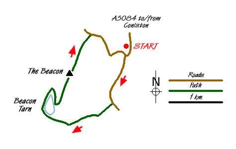
The start is the parking area (grid ref. SD289910) on the left side of the A5084 when driving from the Coniston direction and opposite the entrance to Brown Howe car park on the left. There is enough space for a few cars just before the minor road to Stable Harvey. After parking walk alongside the road to Blawith Common. In places you can walk on a small path developing on the verge along the right hand side.
Just after the parking area on the right look out for a wide grassy path on your left (grid ref. SD286901). Follow this ignoring any minor paths going off either side. Go under the power lines and climb to the flank of Slatestone Fell. The path continues down into the valley. Turn right over the bridge and follow this excellent path as far as the outlet to the tarn (grid ref. SD274903).
Bear left and follow the path along the shore of Beacon Tarn (keeping the tarn to your right). You will get a clear view of the Beacon and potential routes to the summit. My choice of route may not have been the easiest but certainly got me to the top very quickly. Continuing to the northern end of the track, I took a direct and unpathed approach up the fell. This involved a zig-zag route following grassy patches until I reached the summit.
The views are superb. Most impressive is probably an almost complete view of Coniston Water. As mentioned in the introduction you also see the Coniston Fells and the Cumbrian Coast plus a great deal more. To descend follow the clear grassy path that heads roughly north. This easy descent takes you down to a narrow tarmac lane (grid ref. SD282914). Turn right and, despite the tarmac, you will enjoy a wonderful little walk through some wonderful Lakeland country. All too soon you reach the main road. Turn left to reach the start.
Messaging & Social Media
Message Walking Britain and follow the latest news.

Mountain Weather
Stay safe on the mountains with detailed weather forecasts - for iOS devices or for Android devices.