Walk 1189 - printer friendly version
Cannock Chase Circular Walk
Author - Lou Johnson
Length - 6.5 miles / 10.6 km
Ascent - 250 feet / 76 metres
Grade - easy
Start - OS grid reference SJ973208
Lat 52.78477 + Long -2.0414727
Postcode ST17 0UH (approx. location only)
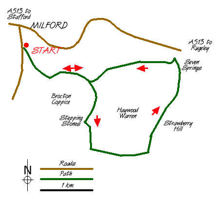
Designated an Area of Outstanding natural Beauty, Cannock Chase in Staffordshire provides a basis for many excellent and easily graded walks. This example provides a perfect introduction to the area including visits to many of my childhood haunts! The walk starts at Milford Common east of Stafford on the A513 to Rugeley. The best place to park is near the "Rest Home" marked as a Hospital (grid ref. SJ973208) where there is ample parking to be found.
After parking take the main path, which enters a cutting, and head south-east to Mere Pits. Leaving the cutting follow the broad path that turns north east. Stay on this turning right (east) to reach the stepping stones over Sher Brook. This is a pleasant place to linger especially mid-week. Cross the stepping stones and follow the clear path on the east side of the brook for about a mile and a half where you turn left (grid ref 988180) at a clear junction.
Stay with this path for just under a mile as it climbs and then levels to reach a broad forestry track (grid ref 998182). Turn north and follow this tracks down Abraham's Valley to reach a car parking area in just under two miles. This 'beauty' spot, known locally as Seven Springs, has a multitude of paths and the one you need turns south west and then west to reach the stepping stones crossed earlier in the walk. All that is left is to retrace your route back to your car.
Cannock Chase has many footpaths and it is a confusing area in which to describe walks. It is therefore suggested that the 1:25,000 map is used.
Messaging & Social Media
Message Walking Britain and follow the latest news.

Mountain Weather
Stay safe on the mountains with detailed weather forecasts - for iOS devices or for Android devices.