Walk 1200 - printer friendly version
Windy Gyle Walk
Author - Lou Johnson
Length - 7.5 miles / 12.2 km
Ascent - 1550 feet / 470 metres
Grade - moderate
Start - OS grid reference NT860114
Lat 55.396347 + Long -2.2225863
Postcode NE65 7BP (approx. location only)
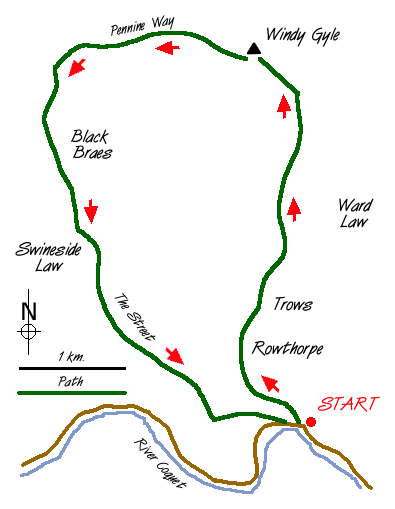
The upper reaches of the Coquet valley in the Northumberland National park provide a great feeling of remoteness. This walk takes to the high ground and starts roughly half a mile west of Windylaugh where ample parking is available on the grass verge near the confluence of Trows Burn with the River Coquet (grid ref. NT860114).
Head up the valley containing Trows Burn on the metalled lane that leads to the lonely farmsteads of Rowthorpe and Trows. Shortly after the latter farm a side track forks left off the valley track and immediately starts to climb quite steeply. After a short way the gradient eases and ahead you can see the large rounded shape of Windy Gyle although the summit will not come into view for some time yet.
Stay with the track with ever improving retrospective views back into Coquetdale. After just short of two miles the track meets a bridleway/footpath (grid ref. 860148). turn left (just north of west) for the final climb to summit of Windy Gyle, which is marked by a large cairn. There are superb views in all directions especially over Scotland.
If the visibility is good, Windy Gyle is a pleasant place to spend some time. All good things must end and you retrace your steps to the fence to pick up the Pennine Way as it heads south. The going is pleasantly easy as the path undulates along the ridge. Reaching a small col just before Mozie Law take the clear path that goes south over Black Braes. Stay with this ridge, choosing the best path for the conditions, over the flanks of Swineside Law. Known as "the Street" this ridge path leads you back to where you have parked.
Although this walk includes a two thousand foot summit the going, apart from a few boggy sections, is remarkably easy. The summit of Windy Gyle is reached without too much exertion and you have plenty of energy to enjoy the "deafening" silence so typical of this part of Britain. Whatever happens the landscape will captivate your imagination and you will certainly return to enjoy more of the Cheviots.
Messaging & Social Media
Message Walking Britain and follow the latest news.

Mountain Weather
Stay safe on the mountains with detailed weather forecasts - for iOS devices or for Android devices.