Walk 1208 - printer friendly version
Ingleborough & Park Fell Walk
Author - Lou Johnson
Length - 7.5 miles / 12.2 km
Ascent - 1560 feet / 473 metres
Grade - moderate
Start - OS grid reference SD746778
Lat 54.195324 + Long -2.3908052
Postcode LA6 3FH (approx. location only)
Ingleborough is the second highest peak in Yorkshire, over-topped by Whernside, with the summit visited by many people each year. This Yorkshire Dales walk follows a less popular route to the summit, providing an enjoyable excursion with good views of Pen-y-ghent and Whernside adding to the interest.
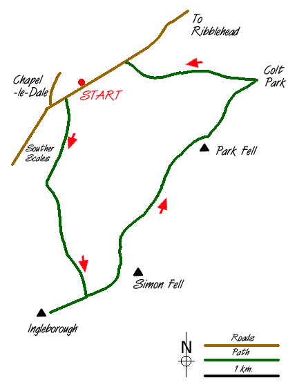
Parking is available in a lay-by (grid ref. SD746778) on the B6255 Ingleton to Hawes road about 2km before Ribblehead. After parking walk around 100 metres down the road towards Ingleton to take a footpath on the left signed "Ingleborough". This leads easily across fields to reach the impressive limestone pavement above South Scales Farm. The onward route is clearly marked with the path exiting onto moorland. The path on this section has been strengthened and progress is quick and easy until you reach the base of the cliffs on the western face of Ingleborough.
The path climbs steeply on a paved section (with one short section of mild scrambling) to reach the col between Simon Fell and Ingleborough. Go through the gate and follow the path onto Ingleborough's extensive summit plateau, which is adorned with a well-built wind shelter, an assortment of cairns and an OS trig column. The views in all directions are good with Pen-y-ghent and Whernside attracting your attention. On days with good visibility the Lakeland Fells look superb on the western skyline.
Retrace you steps to the gate and instead of descending back into the valley follow the path that heads north on the rim of the escarpment. This route offers good views down to Ribblehead viaduct with Whernside providing an equally impressive backdrop. The path continues alongside a wall over Park Fell before descending into Ribblesdale. The descent steepens before reaching grassy pastures near Colt Park Farm.
Turn left just before the farm following the blue waymarks. This path gives further views of Ribblehead viaduct and Whernside with another section of superb limestone pavement completing the walk. Reaching the road turn left and after a few minutes you are back at the lay-by.
Messaging & Social Media
Message Walking Britain and follow the latest news.

Mountain Weather
Stay safe on the mountains with detailed weather forecasts - for iOS devices or for Android devices.