Walk 1213 - printer friendly version
Alport Castles Walk
Author - Lou Johnson
Length - 8.5 miles / 13.8 km
Ascent - 960 feet / 291 metres
Grade - moderate
Start - OS grid reference SK172893
Lat 53.400249 + Long -1.7427794
Postcode S33 0AQ (approx. location only)
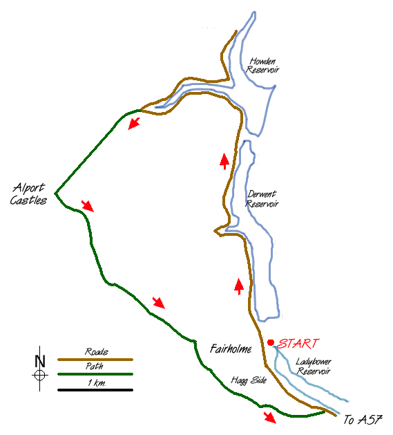
The area around the Derwent valley just north of the A57 from Sheffield to Glossop offers a good starting point for many excellent walks. The starting point, Fairholme car park, is often busy and at peak times (weekends and bank holidays) the road alongside the reservoir is closed to traffic north of this point. This does have benefits as the road walking is surprisingly pleasant on traffic free days. Fairholme also offers an information centre, bike hire, a refreshment kiosk and toilets.
To start this Peak District walk, after parking head back to the road and walk north with the dam wall of the Derwent Reservoir on your right. Used as a practice area for the Lancaster bombers popularly known as the "Dambusters" there is a memorial to the aircrew. (There is also a small museum to the Dambusters aircrew, which is open on most weekends. There is no admission charge although donations are welcome.) Stay on the road, which offers good views across to Back Tor and Margery Hill to reach another dam which holds back the waters of Howden Reservoir.
The majority of the road walking is over and turning west you reach a sharp bend in the road where it doubles back on itself. Just before the bridge over the river turn left along a forest track. After two hundred metres turn left again to join a signed footpath that climbs steadily out of the plantation and on to the moors. Reaching open country the views improve dramatically in all directions especially to the east and north. Stay with this footpath/track to reach Alport Castles. Formed from a massive landslip the location is quite dramatic with a superb view up the valley containing the River Alport towards Bleaklow.
From Alport Castles turn south and follow the ridge path. This descends steadily to bring you to a cross-roads of paths at the western end of Hagg Side Plantation. Here you follow the southern edge of the wood for just under a kilometre to reach a fork in the path (grid ref. 171886) where you turn east and descend to the shores of Ladybower Reservoir. Rather than follow the road take the path that skirts the shore of the reservoir. This is a far more pleasant way to regain your transport at Fairholme.
Messaging & Social Media
Message Walking Britain and follow the latest news.

Mountain Weather
Stay safe on the mountains with detailed weather forecasts - for iOS devices or for Android devices.