Walk 1236 - printer friendly version
Styhead Tarn and Seathwaite Fell Walk
Author - Lou Johnson
Length - 7.0 miles / 11.4 km
Ascent - 1840 feet / 558 metres
Grade - moderate
Start - OS grid reference NY235121
Lat 54.49843 + Long -3.1827147
Postcode CA12 5XJ (approx. location only)
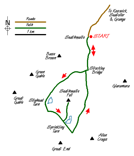
This Lake District walk takes you into the heart of the mountains and is perfect for a shorter day leaving the major summits for another day. Staring from Seathwaite Farm in upper Borrowdale (Grid ref. NY235122) where parking is available on the verge and a car park. A slightly shorter route that omits Seathwaite Fell can be found at Walk 2182 .
After parking head south along the broad track passing between the farm buildings and cottages. Stay on this track as far as Stockley Bridge (Grid ref. 234109). Cross the bridge, go through the gate and head straight up the partially flagged path to Greenhow Knott. On your right is Taylorgill Force waterfall which drops dramatically from the hanging valley above. Reaching a further gate in a cross wall the gradient eases and most of the climbing is over.
The path turns towards the southwest converging on Styhead Gill. Keep the gill on your right and continue to cross a footbridge (grid ref. NY223102). Once across the Gill continue to reach Styhead Tarn. This is a lovely place to rest awhile as you are surrounded by fine mountain scenery including Great Gable, Scafell Pike and Great End. Make your way up to the stretcher box at Styhead where you turn left to pick up the path leading to Sprinkling Tarn.
The easy climb continues to reach the shores of Sprinkling Tarn. Turn left along the eastern shore following an intermittent path, which leads to the highest point of Seathwaite Fell marked by a small cairn. Sadly this fell is always going to play second fiddle to its grander neighbours but nevertheless it is worth exploring as you get grand views of the surrounding mountain scenery.
Return to the main path turning southeast to continue the climb towards Esk Hause. The path meets Ruddy Gill (Grid ref. 229087) which is in a gully. Drop down to cross the Gill and follow the clear path following the east bank of this stream. You descend amidst dramatic scenery on a well maintained path eventually crossing Ruddy Gill to walk parallel to Grains Gill as far as Stockley Bridge. Cross the bridge and head north along the track used for the first section of the walk to reach the start.
Messaging & Social Media
Message Walking Britain and follow the latest news.

Mountain Weather
Stay safe on the mountains with detailed weather forecasts - for iOS devices or for Android devices.