Walk 1266 - printer friendly version
The Old Man of Stoer and the Point of Stoer Walk
Author - Lou Johnson
Length - 4.5 miles / 7.3 km
Ascent - 900 feet / 273 metres
Grade - easy
Start - OS grid reference NC004327
Lat 58.237637 + Long -5.4018339
Postcode IV27 4JH (approx. location only)
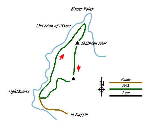
This coastal walk in Assynt on the north-west coast of Scotland offers excellent views of this wild coastline and in particular the sea stack known as the Old Man of Stoer. Much of the walk is over rough ground with little evidence of paths so some navigational skills are required.
The start is the car park (grid ref. NC004327) at the end of the road to the Point of Stoer Lighthouse, which is reached from the scenic B869 Lochinver to Unapool road. After parking, walk north with the sea on your left following one of the many small paths or sheep tracks along the coast. Do not lose height as you have to contend with a small inlet which is easier to get round if you stay above the 50 metre contour.
The coast is rugged and often pummelled by storm force seas especially in winter. Underfoot the going is fairly easy especially if you follow one of the many sheep trods. After passing the small inlet of Geodh' nan Daoine, you traverse a rockier landscape for a while with the hill of Sidhean Mor (161m.) rising to your right. Progress is fast an soon you get your first sight of the Old Man of Stoer rising as an isolated stack of rock from the sea. My first question was "how much longer will it last?" as it stands unprotected from the elements.
After reaching the Old Man continue along the coast to rea Stoer Point. From here the view north along the coast is wonderful with the higher mountains of North Sutherland rising on the distant skyline. This is a great place to spend some time soaking up the solitude and feeling of wilderness. The return to the start begins with a steady climb south to the summit of Sidhean Mor with its trig point. As the latter might suggest the view especially to the northeast is superb.
To continue, descend south aiming for the radio mast. The ground is rough and there is no path so choose your own route. There are a few wetter areas but these can all be avoided. Ignore the track that you cross and continue making a beeline for the radio mast. Once this is reached locate the access track and follow this downhill back to the start.
Messaging & Social Media
Message Walking Britain and follow the latest news.

Mountain Weather
Stay safe on the mountains with detailed weather forecasts - for iOS devices or for Android devices.