Walk 1273 - printer friendly version
Burbage Rocks & Padley Gorge from Hay Wood Walk
Author - Lou Johnson
Length - 11.0 miles / 17.9 km
Ascent - 2040 feet / 618 metres
Grade - moderate
Start - OS grid reference SK255777
Lat 53.295649 + Long -1.6188816
Postcode S32 2HX (approx. location only)
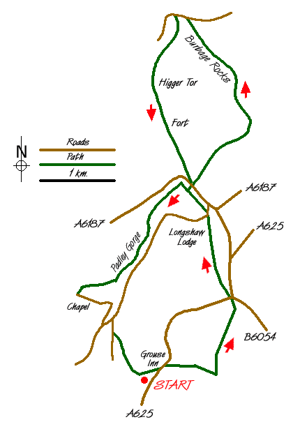
This is a lengthy Peak District walk that takes in many of the highlights of the Peak District National Park in the vicinity of the Longshaw Estate. The start is a small car park (Grid ref. SK255777) at Hay Wood off the B6054 above Froggatt village near the Grouse Inn.
Exit the car park and take the field path that leads to the main road by the Grouse Inn. Turn left along the main road and cross at the footpath sign to take a clear path heading east towards White Edge. Reaching the edge (Grid ref. SK 266778) turn left. Continue north across open moorland to reach a road junction (Grid ref. SK 268789). Go straight across and follow the gated drive leading to Longshaw Lodge where refreshments are usually available in the National Trust cafe. Continue north along the drive to reach a road (Grid ref. SK 265801). Turn right along the road for a short way and cross over to take the footpath on the left. Bear right at the first junction to reach a main road.
Cross over and take the right hand of two tracks. This leads up onto Burbage Moor offering fine views across to Higger Tor. Stay on the higher level passing above the quarries and follow the top level of Burbage Rocks. This is a popular place for climbers. Reaching a road (Grid ref. SK 262829) turn left crossing Upper Burbage Bridge. Take the first path on your left and follow this to Higger Tor.
Descend from Higger Tor towards Carl Wark and continue past the remains of this ancient fort to reach the main road (Grid ref. SK 260807). Cross this busy road and turn left. Take the first path on your right. This path descends to a footbridge. Cross the bridge and continue downhill into pleasant woodland that cloaks Padley Gorge. Note the occasional discarded millstones along the path. Do not be tempted to descend to cross the stream instead continue with the stream to your left to reach an open area with the backs of houses in view (Grid ref. SK 249790).
Ignore the gravel road descending towards Grindleford station instead turning right to contour on a clear path through woodland to reach the obvious remains of the incline that once served Bole Hill quarries. Descend this incline to reach a road/track. Turn left to pass Padley Chapel, which is well worth a closer look. Continue past the station and look for a steep rising path on your left. Take this and climb up to a road. Go straight across along the residential road opposite. After approximately 300 metres turn left at the second of two footpaths. This leads uphill into woodland. The route is hard to describe with many paths in evidence. However at the first major junction fork left, which should lead after a short climb back to the start.
Messaging & Social Media
Message Walking Britain and follow the latest news.

Mountain Weather
Stay safe on the mountains with detailed weather forecasts - for iOS devices or for Android devices.