Walk 1285 - printer friendly version
Dungworth & Rod Moor Walk
Author - Andy Chaplin
Length - 9.4 miles / 15.3 km
Ascent - 1200 feet / 364 metres
Grade - moderate
Start - OS grid reference SK280898
Lat 53.4042830 + Long -1.5803087
Postcode S6 6HF (approx. location only)
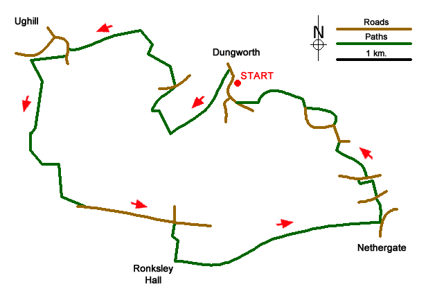
This walk fills in the high ground between the Loxley and Rivelin valleys to the west of Stannington on the western edge of Sheffield. As such it gives good views into both valleys and because it is on the edge of the Peak District, the climbs to the northerly and southerly viewpoints are relatively easy. There is a bus from Hillsborough roughly every 30 minutes with route 61 going one way around the Hillsborough to Bradfield circuit and route 62 the other way around. By car, park in the lay-by at SK 280898 on Yews Lane then walk northwards up towards Dungworth village. Just past the village hall there is a track on the left that heads off south westwards behind Sykehouse Farm and continues in the same direction - as Ringwood Lane then as Cow Gap Lane - but still a farm track. Bradfield church is visible on the hillside over to your right.
When the track ends at a gate in a wall, take the footpath north towards Hall Broom then follow the path to the right of the house and out on the lane to the Sidling Hollow road. Turn left then take the first footpath off on the right - number 113. This crosses the Ughill Brook valley - flowing into Damflask reservoir - and comes up onto Ughill Wood Road.
Walk westwards on Ughill Wood Road until you come to the junction with Corker Lane - the left-hand road at the junction. Follow this to the bridge over the Ughill Beck then take the path off on the right up alongside the stream. This path comes out on Platts Lane - although in some places it is not very well defined. Platts Lane is a farm/moors track that you follow past Platts Farm and Crawshaw Farm (with a slight short cut across a field) to the road at Crawshaw Lodge on Rod Side. It is marked as path No 85. As you cross over the moorland you swap views of the Loxley valley with the Rivelin valley.
Walk eastwards along Rod Side until just after Beeton Rod then turn off right on Moorwood Lane and follow the track down to Ronksley Hall Farm. Then go left and follow the track - still Moorwood Lane - to the farms at The Flash. Carry straight ahead on the path between the buildings - No 73 - which comes out on the outskirts of Nethergate on Oldfield Road.
Take Reynard Road to the junction with Riggs High Road and go straight across onto the footpath - No 68 - up over the hill until you look down onto Stannington Road. The footpath goes to the left here and comes out on Riggs Low Road opposite Underbank Chapel.
Go east past the Chapel then turn off left on the Spoon Lane track which goes across the Storrs Beck valley and comes out on Storrs Lane. Continue north up Storrs Lane and when it turns to the left take the path off between the buildings - No 56. Follow it to the right across fields to the Storrs Green Road then go right along the road and stay on it as it bends left at Storrs Grange houses.
When the road next bends to the right take the lane off on the left - the charmingly named Pudding Poke - and follow it back up to Yews Lane where there is a good view back down the Sykehouse Brook valley towards Stacey Bank (location of the Nags Head - Bradfield Brewery's brewery tap).
Messaging & Social Media
Message Walking Britain and follow the latest news.

Mountain Weather
Stay safe on the mountains with detailed weather forecasts - for iOS devices or for Android devices.