Walk 1286 - printer friendly version
Castleton Great Ridge & Mam Tor Walk
Author - Lou Johnson
Length - 8.5 miles / 13.8 km
Ascent - 1900 feet / 576 metres
Grade - moderate
Start - OS grid reference SK171834
Lat 53.34722 + Long -1.7446005
Postcode S33 6AA (approx. location only)
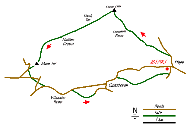
The Great Ridge of Castleton is one of the finest walks in the Peak District. The walk starts from the village of Hope, where parking is available on the south side of the A6187 (Grid ref. SK171834), and ascends Lose Hill before following the Castleton Ridge to Mam Tor. It then descends to Castleton vis Winnats Pass before ending with a pleasant riverside stroll back to Hope.
From the centre of the village, walk north along the Edale road to reach a signed footpath on your left (Grid ref. SK 171838) which is just before the lane down to Kilhill Bridge. Follow this for a short way to a cross path and turn right. This path leads without any further navigational problems to Lose Hill Farm from the where the path continues rather more steeply on to the summit of Lose Hill. A topograph provides details of the extensive panorama that is available from here, which includes Kinder Scout, Win Hill and the length of the Great Castleton Ridge.
Continue along the ridge to Back Tor, Hollins Cross and Mam Tor. The views are good on both sides with Edale to your right and the Hope Valley to your left. Reaching MamTor, you can retrace yoiu route along the Castleton Ridge. Descend from Mam Tor to the road. Turn left and left again down a footpath to reach a road (Grid ref. SK 125831). Go straight across the road to join a footpath taking the left fork when the path divides. Go straight across the next road and continue on the path to Winnats Head Farm.
Follow the road down through Winnats Pass past the entrance to Speedwell cavern to locate a path on your right (Grid ref. SK 139827). Take this path and follow to Castleton village with an excellent view on the left to the Castleton Ridge. Continue through the village and follow the A6187 towards Hope. In under half a kilometre from the village centre take a signed path on your left (Grid ref. SK 153831). Continue on this path crossing a railway line to reach a lane (Grid ref. SK 171832). Turn left up the lane into Hope village.
Note - This walk was undertaken during the Hope village "Well Dressing" and it is worth exploring the village to see the dressed wells. Check with the local tourist information offices for dates.
Messaging & Social Media
Message Walking Britain and follow the latest news.

Mountain Weather
Stay safe on the mountains with detailed weather forecasts - for iOS devices or for Android devices.