Walk 1288 - printer friendly version
Roaches & Hen Cloud from Tittesworth Reservoir Walk
Author - Lou Johnson
Length - 8.5 miles / 13.8 km
Ascent - 1400 feet / 424 metres
Grade - moderate
Start - OS grid reference SJ993602
Lat 53.138952 + Long -2.0119183
Postcode ST13 8SN (approx. location only)
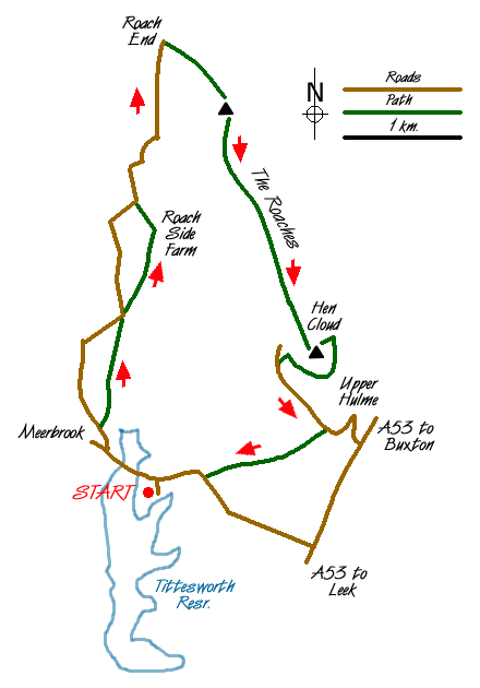
The Roaches are a familiar landmark for anyone driving from Leek to Buxton. The Roaches are a gritstone escarpment providing excellent walking and climbing. A small outlier, Hen Cloud, has also been included in this route. The start is Tittesworth Reservoir, well known for its varied birdlife and the route also includes some of Staffordshire's more attractive countryside.
The start of this Peak District walk is the Tittesworth Reservoir car park (Grid ref. SJ993602) where a charge is levied. Roadside parking is also available nearby. From the car park retrace your steps to the road and turn left into the hamlet of Meerbrook. Turn right at the road junction and continue along the road for a short way. Take the first footpath on your right and follow this through to Greenlane. Here you join the road for a short way before following another footpath on your right that leads across fields to Roach Side Farm and the road (Grid ref. SJ 993630). Turn right along the lane, which sees very little traffic, as far as Roach End (Grid ref. SJ 995645).
Turn right along the flagged path that leads south along the Roaches escarpment. The views are good and usually you will see climbers on the crags. After passing Doxey Pool drop down to the front edge of the escarpment at Rockhall. From here skirt the end of the crags and follow the footpath through a field and begin the ascent of Hen Cloud.
The Descent from Hen Cloud is confusing. However from the summit area head northeast and descend into the wood. Here you will join a clear path that should be followed south. This path exits the woods and becomes a track. Follow this to the lane. Turn left and follow the lane towards Upper Hulme. After passing some cottages on the left locate a wide driveway into a farm on your right (Grid ref. SK 010608). The unsigned right of way passes to the right of the buildings and then becomes clearly marked. This path leads across fields to reach a road (Grid ref SJ 999604). Turn right and the start is a few minutes along this road.
Messaging & Social Media
Message Walking Britain and follow the latest news.

Mountain Weather
Stay safe on the mountains with detailed weather forecasts - for iOS devices or for Android devices.