Walk 1300 - printer friendly version
Hope Cross & Ringing Roger Walk
Author - Lou Johnson
Length - 8.0 miles / 13 km
Ascent - 1700 feet / 515 metres
Grade - moderate
Start - OS grid reference SK124853
Lat 53.364428 + Long -1.8151258
Postcode S33 7ZQ (approx. location only)
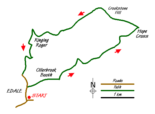
This Peak District walk explores the quieter eastern section of the Kinder Plateau. The route starts from the main car park in Edale (grid ref. SK124853). There is also a public transport option with Edale station served by trains on the Manchester and Stockport to Sheffield route. The walk begins by using field paths linking the farms of the Edale Valley before climbing onto the moors of Kinder.
Exit the car park and walk north into the village. Go past the campsite and the National Park information centre on your right and then take the signed footpath to Ollerbrook Booth, which also on your right. Follow the waymarked route through the buildings at Ollerbrook Booth and, still heading east, cross more fields on the path to Nether Booth Farm. After passing Cotefield (on your left) turn left at the footpath junction (grid ref SK133859). This leads you uphill with the path following the edge of Open Country to reach the Youth Hostel at Rowland Gate (grid ref SK140865). Signs direct you on to the path towards Clough Farm, where some careful navigation is required to stay on the route. As a general comment bear left and providing you stay on a path you can't really go too wrong.
The path climbs again to enter Open Country and continues its ascent across open moorland to enter Jagger's Clough. Continue on the main track to climb up onto the ridge linking Win Hill with the Kinder Plateau (grid ref SK159876). From here you get your first view north towards the Derwent Valley and the surrounding high moorland. You can make a short diversion south to Hope Cross, which stands on the route of the old Roman road that originally linked Hope to Glossop. There are a number of paths at this important junction and it is important that you locate the right one, which is the clear track heading northwest onto Crookstone Hill.
The track soon reduces to a footpath, which turns southwest across Crookstone Out Moor becoming a well trodden path along the southern edge of Kinder. The views across Edale to the Castleton Ridge are excellent. The going is fairly level and you need to have map in hand ready to identify where you cross Ollerbrook Clough (grid ref. SK129874). Since the OS 1:25000 map was surveyed a number of additional fences have been constructed in this vicinity so careful navigation is necessary. However the general aim is to leave the edge path as it continues towards Golden Clough and Grindsbrook, and follow the small ridge southwest to the rocky prominence of Ringing Roger (grid ref. SK125872). This is best by keeping to the ridge and using the stiles to cross the new fences.
From Ringing Roger you get a bird's eye view of Grindsbrook and Edale. You can also plot your route into the valley as the path used for the descent as it zigzags down to the Nab and continues into the Grindsbrook valley. Once you join the main valley path, bear left, cross the footbridge, pass the Old Nags Head (the start or finish of the Pennine Way) and follow the lane back down to the start.
Messaging & Social Media
Message Walking Britain and follow the latest news.

Mountain Weather
Stay safe on the mountains with detailed weather forecasts - for iOS devices or for Android devices.