Walk 1301 - printer friendly version
Great Stickle & Stickle Pike Walk
Author - Lou Johnson
Length - 5.0 miles / 8.1 km
Ascent - 1450 feet / 439 metres
Grade - moderate
Start - OS grid reference SD198920
Lat 54.317261 + Long -3.2343926
Postcode LA20 6DT (approx. location only)
The Duddon Valley or Dunnerdale in south-west Lakeland, is scenically interesting, flanked in its lower reaches by lower fells. The village of Ulpha, roughly a third of the way up the valley, is where the higher fells begin. Although this Lake District walk does not include any of the high fells it is nevertheless a route that offers many of the characteristics of the more lofty neighbours and makes a perfect half day excursion.
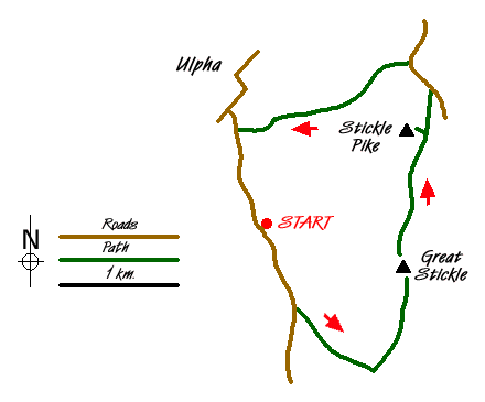
The start is the small car park (SD198920) on the east side of the valley road about a kilometre south of Ulpha village. After parking walk south along the road for a kilometre to the point where a path heads (Grid ref. 202 912) towards an obvious miniature "gorge" slightly ahead on your left. This path climbs quickly and easily on a well prepared grade towards Pickthall Ground.
Once through the "gorge" the path levels and continues towards a wall (Grid ref. SD 206 907). Do not cross the wall but turn left and follow a grassy track beside the wall with Great Stickle rising ahead. The path to its summit is clear although there is a deceptive amount of ascent in the climb to the trig point. The view is wide and varied from Morecambe Bay in the south to the higher fells further up the Duddon Valley.
Descend north from the summit and maintain this general direction towards Stickle Pike using sheep trods and paths. You need to continue to the east or right hand flank from where a steep path leads you to the cairn located on a wonderful little summit. The views are similar to the previous summit although the distinctive shape of Caw dominates to the north.
Use the same path to descend to the east and turn north with Stickle Tarn on your right to reach the road (Grid ref. SD 214 932). Turn left along the road and just before the cross wall (Grid ref. SD 212 934) turn left along a clear path. This path roughly follows the wall in early stages but does trend away to cross Hollow Moss Beck. After crossing this stream head towards Birks (Grid ref. SD 200 930) where you join a rough track that leads down to the road. Turn left and return to the car park.
Messaging & Social Media
Message Walking Britain and follow the latest news.

Mountain Weather
Stay safe on the mountains with detailed weather forecasts - for iOS devices or for Android devices.