Walk 1330 - printer friendly version
Roseberry Topping & Captain Cook's Monument Walk
Author - Peter Smyly
Length - 6.5 miles / 10.6 km
Ascent - 1200 feet / 364 metres
Grade - easy/mod
Start - OS grid reference NZ574108
Lat 54.4893 + Long -1.1154282
Postcode TS9 6HQ (approx. location only)
Roseberry Topping may sound like something out of the desserts section of a cookery book, but in fact it refers to a prominent hill (1,049 feet high) on the border between North Yorkshire and the borough of Redcar and Cleveland. Its conical shape has even drawn comparisons with the Swiss Matterhorn and its reputation owes much to its location as there is nothing else quite like it in the Middlesbrough area.
To avoid a "there and back" scenario, this North York Moors walk describes a more varied and satisfying circular route that also includes part of Newton Moor and Captain Cook's Monument on Easby Moor. The walk can be done without a car if you travel by train to Great Ayton.
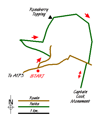
From Great Ayton rail station (grid ref NZ574108), cross the rail bridge and follow Dikes Lane between fields and hedgerows. After a few hundred yards, the road narrows between two buildings. Turn left down Aireyholme Lane before you reach this point. Aireyholme Lane goes down into a dip and then up again before a stile on the left (grid ref. NZ578112) leads to a path across a field to Cliff Ridge Wood. Follow the path ahead through the wood until you reach a dividing of the ways. At this point, turn right up the hill to emerge from the woods onto a grassy slope, the lower part of a field. On topping the brow, Roseberry Topping, which has remained elusively out of sight thus far since leaving the rail station, now appears on the horizon beyond Aireyholme Farm. Bear left and follow the edge of the field to cross over a wooden stile, after which you can follow a path straight ahead, and next to the field, with the initial objective of Roseberry Topping clearly in front of you on the horizon.
As you start to gain height, a stone folly is reached on the left. At this point you may be able to see people already at the top of Roseberry Topping, looking at the view. The most striking feature of the hill at this point is the cliffs to the left. The path leads up to the right, gently at first, before turning more steeply to the left to reach the top. Despite the steep rocky drop off to one side, the summit area offers safe opportunities to walk about and see the views in different directions. The views include looking down on Great Ayton, across to Captain Cook's Monument (a view which will be seen in reverse later in the walk) and the North Sea can be seen to the east. The summit is marked by a white trig point (grid ref. NZ579125).
Next, leave the summit by following the well-constructed path (slightly north of east) down to a col and then up more gently the other side with Slacks Wood appearing on the right and the purple heather of Newton Moor on the left. Before the path goes round the corner to the right, there is a fine retrospective view of Roseberry Topping. The path then skirts Slacks Wood on the right and it offers no difficulty from a route finding point of view as, by following the way ahead you descend to the car park at Gribdale Terrace. The route continues on the other side of the road and a walk of about half a mile up through the woods leads to open moorland and the 51 foot high obelisk of Captain Cook's Monument appears over the horizon on Easby Moor.
Now return to the car park at Gribdale Terrace and take the tarmac road to the left which winds its way all the way back down to return to the walk's start point.
Messaging & Social Media
Message Walking Britain and follow the latest news.

Mountain Weather
Stay safe on the mountains with detailed weather forecasts - for iOS devices or for Android devices.