Walk 1353 - printer friendly version
Pluckley village circular Walk
Author - Lou Johnson
Length - 3.7 miles / 6 km
Ascent - 300 feet / 91 metres
Grade - easy
Start - OS grid reference TQ922433
Lat 51.156667 + Long 0.7471071
Postcode TN27 0RR (approx. location only)
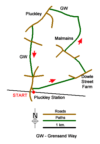
This easy walk in the Kent countryside starts from Pluckley Station (grid ref. TQ922433) which is served by regular trains from Ramsgate, Canterbury, Sevenoaks and London Charing Cross. The route includes pleasant landscapes of orchards, pasture of woodland coppice and the pleasant village of Pluckley with its parish church dating back some 900 years.
From the station walk down the access drive to the Dering Arms. Bear right in front of the pub down a tarmac lane and continue into a field. Cross the field to a stile in the left-hand corner and continue straight ahead across a pasture to reach a lane (grid ref. TQ933436). Bear right along the lane and continue towards Dowle Street Farm. After just over 250 metres turn left onto a signed footpath towards Gore Court. The path goes to the right of the property to join a track. This leads to a lane (grid ref. TQ932441). Bear left along this lane. After approximately 300 metres you pass a large cottage on your left. In the right hand hedge you will find a footpath sign and wooden gate with an adjacent stile. Take this path with the field boundary on your immediate right to pass Malmains on your left. Cross stile into an orchard following the right of way which soon becomes a track to reach Shearland Farm (grid ref. TQ933452).
Before reaching the farm, turn left onto the Greensand Way and continue through orchards and across a recreational ground to reach a road in Pluckley (grid ref TQ926454). Turn left down Smarden Road towards Pluckley Thorne. You are now on the Greensand Way Spur. Continue along the road for just under 700 metres and locate a footpath on the left (grid ref. TQ921450) by a garage. The path leads through several fields to reach Lambden Road (grid ref. TQ921446). Turn left and then right over a stile by a metal gate and into a field. Head south aiming for the left-hand corner of this field from where the path continues in a southerly direction to join Station Road (grid ref. TQ921437). Turn right and walk back to the station.
Messaging & Social Media
Message Walking Britain and follow the latest news.

Mountain Weather
Stay safe on the mountains with detailed weather forecasts - for iOS devices or for Android devices.