Walk 1368 - printer friendly version
Mam Tor, Upper Booth & Rushup Edge Walk
Author - Lou Johnson
Length - 7.0 miles / 11.4 km
Ascent - 1200 feet / 364 metres
Grade - moderate
Start - OS grid reference SK123832
Lat 53.345554 + Long -1.8167094
Postcode S33 8WA (approx. location only)
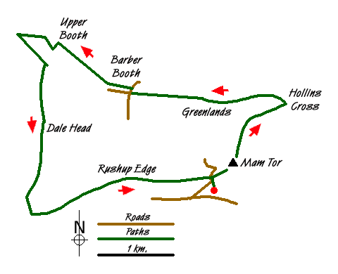
This Peak District walk explores some of the highlights of Edale and its surrounding hills. The walk includes the well known viewpoint of Mam Tor and the adjoining Castleton Ridge. The walk then descends into Edale and explores some less walked paths before climbing onto Rushup Edge at the end of the route.
The walk starts in the large pay and display car park (grid ref. SK123832) just south of Man Nick, near Castleton. There is also come on-road parking in the vicinity if you want to avoid the parking charge. Exit the car park to the north climbing the steps and follow the clear path up to Mam Nick to reach the road.
Bear right and continue to climb the steps and path leading to the summit of Mam Tor from where there are substantial views across the surrounding area. The view north towards Edale and the Kinder Plateau is of particular interest as you will be traversing some of this area as the walk proceeds. Continue along the Castleton Ridge descending along the clear path to reach Hollin's Cross (grid ref. SK135845).
Turn left here, taking the left hand path downwards and following the sign to Barber Booth. Initially the path descends quite quickly but becomes less steep as you lose height. The route runs to the north of Greenlands to join a lane. Turn right and walk north towards Edale. The lane bears right and just afterwards take the stile on the left (grid ref. SK123846). The path crosses a number of fields using stiles and gates, eventually reaching a road (grid ref. SK113846).
At the road, go right. This leads you to the hamlet of Barber Booth. Take the first track on the left and follow this over the railway (grid ref. SK111848). The track bears left over the railway and follow the sometimes feint route, Where the path is unclear head for the farm buildings ahead to reach Upper Booth (grid ref. SK102853). Turn left in the hamlet and then right onto the Pennine Way following in towards Jacob's ladder. Just before Lee House, look for gate below a grassy area on left hand side (grid ref. SK097854). Follow the path towards Highfield heading south at grid ref. SK101850 towards Dale Head.
From Dale Head continue in a southerly direction following the sign to Whitemoor Clough. A steep climb lies ahead onto Rushup Edge. When the path flattens out (grid ref. SK099829), turn left and follow the edge eastwards to Reach Mam Nick. Follow the path and steps down to the car park.
Messaging & Social Media
Message Walking Britain and follow the latest news.

Mountain Weather
Stay safe on the mountains with detailed weather forecasts - for iOS devices or for Android devices.