Walk 1370 - printer friendly version
Sherbrook Valley from Punch Bowl, Milford Walk
Author - Lou Johnson
Length - 4.0 miles / 6.5 km
Ascent - 350 feet / 106 metres
Grade - easy
Start - OS grid reference SJ983207
Lat 52.783875 + Long -2.0266454
Postcode ST17 0UP (approx. location only)
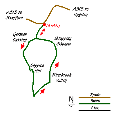
This circular Cannock Chase walk starts from the Punch Bowl free car park located on the south side of the A513 about a mile east of Milford Common (grid ref. SJ983207). The route follows sections of the Heart of England and Staffordshire Way covering both woodland and open heathland typical of Cannock Chase. Generally route finding is relatively easy although the section on Coppice Hill can be confusing so a suitable map is useful.
After parking, walk south west along the clear rising path (Staffordshire Way) with a fence on your left. Ignore minor paths disappearing into the woodland on your right. Soon the path starts to descend to reach a junction (grid ref. SJ980202). Leave the Staffordshire which bear left and turn right along a broad path/track to reach another obvious junction (grid ref. SJ978201) after about 300 metres. On your right you will see the "German Cutting" which used to contain a railway that led up to the First World War camps that once covered Cannock Chase. Turn left here and follow the Heart of England Way as it climbs steadily through woodland. You will see Mere Pits (a pond) on your right.
Stay on the Heart of England Way following the widest of the tracks at each subsequent junction - basically keeping straight ahead. This will lead you into more a more open area and a car park (grid ref. SJ979180). Navigation here is difficult to describe as there are many paths in the vicinity of the car park. However on reaching the car park, turn left and walk about 50 metres and then turn left. Still following the Heart Of England Way. This is where the map becomes useful!
The Heart of England Way is a broad path crossing open heathland. Ahead you will see the Post Office Communication Tower and this provides a perfect landmark. To your left you can see across the Sherbrook Valley to some of the forested areas of Cannock Chase. Sadly signs are in short supply. After approximately 600m metres you will arrive at the junction with the Staffordshire Way (grid ref. SJ980184). Turn right here and descend into Sherbrook Valley.
Reaching the path/track along the valley floor (grid ref. SJ985187), turn left staying on the Staffordshire Way which is now heading north. The Sherbrook is on your right. Continue following this clear path as it follows the stream. After just over a kilometre you will reach the steeping stones across the Sherbrook. Do not cross and continue along the Staffordshire Way to reach the first junction you encountered at the start of the walk (grid ref. SJ980202). Turn right here and the car park is a short walk away.
Messaging & Social Media
Message Walking Britain and follow the latest news.

Mountain Weather
Stay safe on the mountains with detailed weather forecasts - for iOS devices or for Android devices.