Walk 1378 - printer friendly version
Carsington Circular Walk
Author - Lou Johnson
Length - 4.5 miles / 7.3 km
Ascent - 650 feet / 197 metres
Grade - easy
Start - OS grid reference SK230543
Lat 53.085427 + Long -1.6580647
Postcode DE4 4NT (approx. location only)
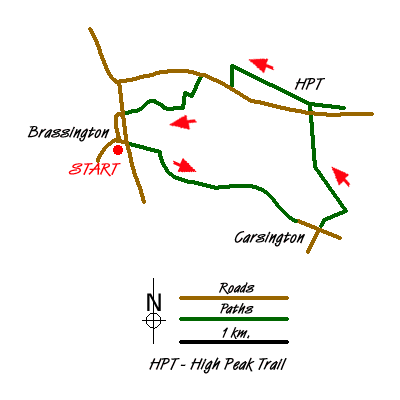
The village of Brassington is situated just outside the boundaries of the Peak District National Park but still retains the characteristics of the White Peak with dry stone walls and stone built cottages. This walk combines a variety of paths and quiet country lanes to explore the area between the village and the High Peak Trail and includes a visit to nearby Carsington.
There is some on street parking within the village (grid ref. SK230543) by the church. However do be considerate when parking and ensure that you are not causing inconvenience for residents. After parking and with your back to the church, walk down the street opposite with the Miner's Arms pub on your right. Reaching the main road through the village, Town Street, cross the road, and take the signed footpath opposite. This leads into fields and climbs almost immediately on a clear path to reach a wall (grid ref. SK234542). Turn right here and follow the clear path or track as it contours around the hillside offering a grandstand view of Brassington. This path leads to a crossing with a farm track (grid ref. SK238539). Continue ahead climbing slightly. The onward path is clear and begins to descend into Carsington village. There are views over Carsington Reservoir on your right.
Joining the tarmac lane in Carsington continue ahead to a road junction (grid ref. SK251534). At this junction, go left up a lane lined with cottages. There is a footpath sign. This path leads onto the open hillside and the path climbs steeply with views to the right over the village. The path initially trends towards a wall on the opposite side of the field before bearing left to complete the ascent beside this wall. Nearing the top you will pass a limestone outcrop on the other side of the wall called the King's Chair.
Away to your left is a recently constructed wind farm which has somewhat spoiled the immediate surroundings of Carsington Pasture. The path continues more easily to a lane. Turn right for a few yards and then cross the road and join the High Peak Trail. Our route is going left (west) along the Trail but it is worth walking a short way right (east) to see one of the former inclines on the Cromford and High Peak Railway.
Heading west along the High Peak Trail you will notice that there is evidence of former and current industry, perhaps the reason for this area's exclusion from the National Park. After about one kilometre you reach a factory on the left hand side of the trail. On your right can be seen Harboro Rocks a popular venue for climbers. Just before the factory there is a signed footpath on the left (grid ref. SK242550). Turn left down this path to a road. Bear right along the road, Manystones Lane, for a short way to locate a footpath on the left (grid ref. SK239549).
Take this clear footpath which makes a dog leg to reach another lane (grid ref. SK237546). Turn right along this quiet almost traffic free lane into Brassington. On reaching the main road, turn left, and walk downhill into the village.
Messaging & Social Media
Message Walking Britain and follow the latest news.

Mountain Weather
Stay safe on the mountains with detailed weather forecasts - for iOS devices or for Android devices.