Walk 1467 - printer friendly version
Cleveland Way - Roseberry Common to Tidy Brown Hill Walk
Author - Andy Chaplin
Length - 15.0 miles / 24.4 km
Ascent - 2000 feet / 606 metres
Grade - moderate
Start - OS grid reference NZ592110
Lat 54.4908911 + Long -1.087605501
Postcode TS9 6HN (approx. location only)
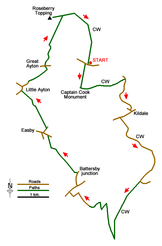
This North York Moors walk is part of a series of circular walks that cover the Cleveland Way from Slapewath. This section takes in the stunning views around Roseberry Topping, Kildale and Baysdale as well as the historically interesting Captain Cook monument, Battersby Junction and incline, information boards at Aireyholme Farm and Roseberry Mines and the WW2 RAF memorials on Easby Moor and at Kildale.
From the ample car parking at Gribdale on Dikes Lane (grid ref. NZ592110) take the Cleveland Way south in the direction of Kildale for ½ mile to the Captain Cook Monument. The path is not signposted at the Monument - but it is the one on the left on the opposite side of the Monument to the commemorative plaque. Stay on the Cleveland Way for another mile until you reach the road at Pale End Plantation.
Turn right on the road past Bankside Farm and under the railway to Kildale. At Glebe Cottage turn left and then right - still following signs for the Cleveland Way along the main road through the village. Turn off left up the road to Baysdale Farm. The Cleveland Way sign is overgrown by the hedgerow at this turn so it can be easy to miss (grid ref. NZ603901).
Carry on uphill along the road for 1.5 miles over two cattle grids until the road bends around to the left on its way to Baysdale Farm (grid ref. NZ610070). At this point follow the Cleveland Way straight ahead through the gate and along the moor track for 1.75 miles until the Cleveland Way is signposted off to the left at Tidy Brown Hill (grid ref. NZ601050).
At this point you leave the Cleveland Way and turn right along the moor track that heads downhill along Greenhow Ingleby Bank towards Roseberry Topping in the distance. Continue for a mile through the gates at Ingleby Bank and at Bank Foot Farm. Carry straight on along the road to the main Stone Stoup Hill road (rid ref. NZ585065) then turn right and then left following signs to Battersby Junction. The station is unusual now that the track heading westwards is no longer used.
Cross over the tracks then go through the two gates on the far side. Walk for half a mile across the fields keeping the hedge and fence on your left and heading towards Fir Tree Farm. In the last field keep to the edge all the way around on your right and back again to the farm. Cross over the double stile, go straight over the "1-hole golf course" and pass on the right of the farm. Take the path through the trees then across the field with Mushroom Farm on your right. Follow the telephone wires towards Pilly Hall Farm then take the gate to your right and pass through the farm to the road (grid ref. NZ578085).
Take the road on the right to Low Easby then the first footpath off on the left which goes down what looks like the drive for the house on the left - not the modern house on the right - and leads to a stile at the end. Carry on across two fields keeping the hedge on your left, then over a stile and along two footpath "corridors" for a quarter of a mile then cross the field towards Woodhouse Farm. Pass to the left of the farm then turn off to the right, over a stile, to walk alongside the river Leven. Stay on the path between the river and the deer farm fence then pass through the deserted farm buildings onto Cross Lane (grid ref. NZ569101).
Turn right into Little Ayton, go over the river bridge then turn right past Fletchers Farm coffee shop and campsite. Go over the railway bridge and straight on through the gate and along the track to the road. Turn left and at the crossroads go straight over along Aireyholme Road to Aireyholme Farm. At the farm bear right at the pond, pass the outbuildings on your left and take the track that leads up towards the site of Roseberry Mines keeping to the right of Roseberry Topping. At the end of the track turn right through the gate (grid ref. NZ583127) and climb up the Cleveland Way to Roseberry Topping. Go through the gate at the top then bear right on the Cleveland Way back towards Gribdale with the Captain Cook Monument visible on the opposite hillside in the distance.

Mountain Weather
Stay safe on the mountains with detailed weather forecasts - for iOS devices or for Android devices.

