Walk 1502 - printer friendly version
Shutlingsloe and Macclesfield Forest from Trentabank Walk
Author - Lou Johnson
Length - 9.0 miles / 14.6 km
Ascent - 2000 feet / 606 metres
Grade - moderate
Start - OS grid reference SJ961711
Lat 53.236916 + Long -2.0598902
Postcode SK11 0NS (approx. location only)
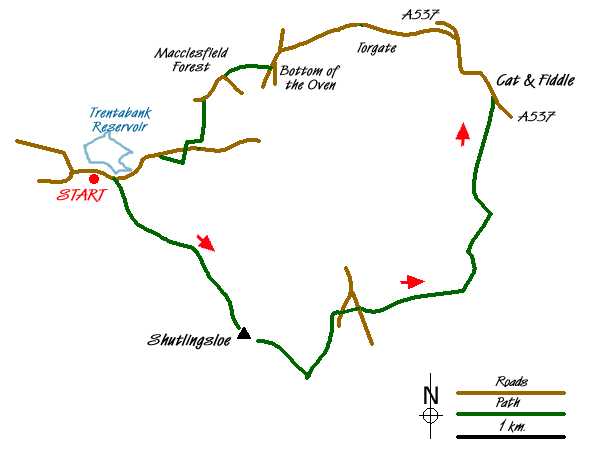
This Peak District walk explores the scenic Cheshire sector of the National Park. The route offers scenic interest and is generally well waymarked. There is one section of road walking and care is needed on this part of the route. The first objective is known locally as the "Cheshire Matterhorn", Shutlingsloe has a distinctive outline when viewed from certain directions and it is easy to see why it earned this nickname. Besides the scenic interest the walk visits the hamlet of Macclesfield Forest where the famous Rushing Bearing Service is held in the chapel each August.
The start is the small car park adjacent to the visitor centre at Trentabank (Grid ref. SJ961711). After parking, walk back towards the road and turn right along the footpath that runs parallel to the road. Ignore the first path right and continue a short way further along by the road to reach the second path going right. Take this and start to climb into the woods. Keep straight ahead at the next junction and continue to climb.
The end of the woodland is in sight when a track comes in from the right. Continue ahead here looking out for a signed path on your right to Shutlingsloe. Take this, and leave the forest for High Moor. The path is paved and progress fast and soon you get your first sight of your objective. Reaching a wall, go through the gate and turn right, keeping the wall on your immediate right. This path will lead without any further need for navigation to the summit area. The views are extensive with most of the onward route in view plus other highlights of the area including the Roaches over the border in neighbouring Staffordshire.
Descend from the summit by the steep path on the eastern flank descending across rough pasture to reach a lane (Grid ref. SJ982690). Turn left along here, go past Banktop and continue along the edge of a wood to reach a road (Grid ref. SJ986697). Go straight across over the bridge into a farmyard. Reaching another lane, go straight across again and follow Cumberland Brook. At the fork (Grid ref SJ998699) bear left. A steady ascent leads onto the open moor and a footpath junction (Grid ref. SK001707). Turn left and continue to the A537. Cross the road with care and turn left (north). Where the A537 bends left, go straight ahead on the track. Reaching the A537 again, cross the road with care and follow the minor road descending towards Bottom of the Oven. Please note that the A537 is a dangerous road and extreme care is needed at all times.
This is quite a fast section of road and it is wise to stay on the right hand side facing uphill traffic. Passing the Pub on your right, turn left along the lane, forking right at the next junction. Turn right up a narrow walled lane, Oven Lane, which leads up to the small hamlet of Macclesfield Forest (Grid ref. SJ974721). Passing the chapel, go straight ahead at the road junction and after a short section of road walking, turn left down a path (Grid ref. SJ972719) alongside the woods. The path enters the woods after a short way and descends towards the road. Just before reaching the road take the path on your right. Reaching the road, cross over and continue on the path opposite which leads through the woods before running parallel to the road back to the start.
Messaging & Social Media
Message Walking Britain and follow the latest news.

Mountain Weather
Stay safe on the mountains with detailed weather forecasts - for iOS devices or for Android devices.