Walk 1525 - printer friendly version
Beck Dale & Rievaulx from Helmsley Walk
Author - Michael Chinn
Length - 9.8 miles / 15.8 km
Ascent - 1000 feet / 303 metres
Grade - moderate
Start - OS grid reference SE609838
Lat 54.246274 + Long -1.0669215
Postcode YO62 5AZ (approx. location only)
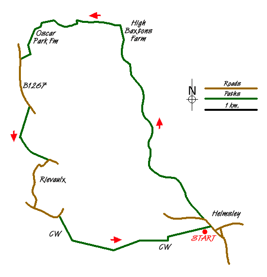
This is the final stage in a series of circular North York Moors walks around the Cleveland Way. It starts and finishes in Helmsley where you can either park in the pay-and-display off the aptly named Cleveland Way (which is quite expensive) or further out of the centre of town which can be difficult particularly during the simmer months. Alternative free parking is available in the lay-by on the B1257, opposite the turn off for Hawnby, which is also on route. The route takes in Beck Dale, the River Rye, Rievaulx Abbey and Helmsley Castle and completes the section of the Cleveland Way from Rievaulx bridge to Helmsley.
Take the B1257 out of town signposted towards Stokesley. After passing a sign to the Roman Catholic Church on your right, in a few yards, take the footpath immediately off on the right. It goes alongside the beck then crosses the beck via a footbridge. Go left after crossing the footbridge. Continue up the track, passing a sawmill on your left, up Beck Dale which feels pleasantly secluded but not overwhelmed by the woods on either side.
The main path is clearly signed through Beckdale East Wood, Ouldray Wood and Collier Hag Wood. After 3.5km, take the main path uphill to the right when you will reach a path signposted to your left. The path goes through the wood skirting a field on your right to a meeting of paths (grid ref. SE594877) as you emerge from the trees.
With a signed gate to your right your path is immediately downhill to your left, look carefully as it may not be immediately obvious. Descend the path towards the beck, cross it and climb up the far side following the path as it bends to your left. Cross straight over the main path.
The path becomes unclear and difficult to follow. Most importantly keep heading west as you zig zag along through the woods. You should pass a two-way path sign. After 1.5kms, you should emerge onto a meeting of paths. Follow the main path to the right which gently descends. Where it levels out and joins a meeting of paths, take the obvious track on your left and follow this uphill and to your right. You will come out at a gate overlooking Oscar Park Farm to your left (grid ref. SE578882).
Take the track along the side of the field, then head towards Oscar Park Farm, going through the farmyard to follow the farm track to emerge on to the B1257. Turn left along the road. After 100m there is a reasonably wide grass verge on the left-hand side and although the road can be busy it is a safe walk to the track off on the right opposite the MP at grid ref. SE574865.
Go through the metal gate set slightly back from the road and follow this track downhill, with good views to the abbey as you descend to reach the road at Rievaulx Church. Turn right through Rievaulx and pass the remains of the abbey as you walk down the road towards Rievaulx Bridge. Turn left on the road away from the bridge and continue along the CW, initially along the road, then off on the track that climbs up through Quarry Bank Wood then skirts Whinny Bank Wood and Blackdale Howl Wood.
As you approach Helmsley there are good views to the right of the castle below you and you enter Helmsley on the road past the pay and display car park on Cleveland Way.
Messaging & Social Media
Message Walking Britain and follow the latest news.

Mountain Weather
Stay safe on the mountains with detailed weather forecasts - for iOS devices or for Android devices.