Walk 1569 - printer friendly version
Lathkill Dale & Bradford Dale Walk
Author - Lou Johnson
Length - 8.2 miles / 13.3 km
Ascent - 1000 feet / 303 metres
Grade - easy/mod
Start - OS grid reference SK192644
Lat 53.176364 + Long -1.7141962
Postcode DE45 1LW (approx. location only)
This varied Peak District walk traverses a section of the pretty Lathkill Dale, offers the chance to visit the village of Youlgreave and includes a section of Bradford Dale. Walking is generally easy and the route is mostly well signed. Opportunities for refreshment are limited and a visit to Youlgreave is necessary to quench your thirst.
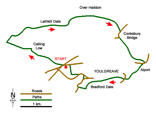
Roadside parking is available on Back Lane at grid ref. SK192644 or the small car park a short distance away at SK194644. Having parked follow the well-trodden Limestone Way west towards Monyash. The path is clear and crosses a number of fields to reach Low Moor Plantation. The onward route takes you past Calling Low, where the path deviates to the north of this farm. Shortly afterwards the views open out ahead and you get your first look at Lathkill Dale across to your right.
The path descends steps to the bottom of Cales Dale (grid ref. SK172653), where you turn right and follow the bottom of the dale north. You soon reach Lathkill Dale, which at this point is open and a typical landscape of the Limestone dales. Reaching the main dale, cross the footbridge (grid ref. SK174655) and turn right on a clear path.
Follow this path down the dale, entering Palmerston Wood. The dale loses its open character and you have a pleasant walk through woodland. Alongside is the River Lathkill, which after very dry weather can dry up. Stay on the main path. There is no need to worry about navigation. It is a simple case of following your nose! You reach a bridge below Over Haddon (grid ref. SK202661) after which the character of the dale starts to change.
Conksbury Bridge (grid ref SK211656) is the next landmark. Here you cross the bridge using the road and walk a short way along the lane before taking the first footpath on your left. This leads you through walled fields down to the main road at Alport (grid ref. SK220645). Cross the road and take the signed footpath opposite. This leads you up Bradford Dale with the River Bradford on your right. Continue alongside the River to reach Mawstone Lane (grid ref SK213639).
Cross the river here and take the path on your left. You are now back on the Limestone Way. The river is now on your left and is followed upstream with the village of Youlgreave high above you on your right. At the next footbridge (grid ref. SK208640) you can reach the village centre by following the lane on your right uphill. To continue, cross the River Bradford here and follow the dale upstream with the river once again on your right.
At grid ref. SK199636, the Limestone Way turns right across the River Bradford. Once across ignore the minor path on your right taking the wider path as it climbs uphill to reach a road (grid ref. SK197637). Turn right along the road and follow the pavement past Lomberdale Hall on your left. Shortly after, there is a signed footpath on the other side of the road on your left. Take this uphill to reach another lane (grid ref. SK198641). Ignore the footpath opposite; instead turn left along the road for a short distance to take the Limestone Way signed on your right. This climbs out of the Dale and you are soon back at either the car park or roadside parking. If you are lucky the ice-cream man may be waiting for you to return!
Messaging & Social Media
Message Walking Britain and follow the latest news.

Mountain Weather
Stay safe on the mountains with detailed weather forecasts - for iOS devices or for Android devices.