Walk 1593 - printer friendly version
Beresford, Wolfscote & Biggin Dales from Hartington Walk
Author - Lou Johnson
Length - 6.2 miles / 10.1 km
Ascent - 500 feet / 152 metres
Grade - easy/mod
Start - OS grid reference SK128605
Lat 53.1414980 + Long -1.8101033
Postcode SK17 0AW (approx. location only)
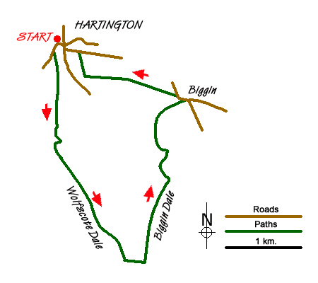
This Peak District walk starts from the village of Hartington, which is a good centre for walkers. The village, with its green and duck pond, has a range of places to eat and usually has ample parking. On busy days you may have to use the pay and display car park on the B5054 a short way from the centre in the direction of Hulme End. This walk explores Wolfscote Dale, through which the River Dove flows and the adjoining Biggin Dale, which for most of the year is a dry valley. The landscape is typical of the 'White Peak' with limestone outcrops common in this area.
To start the walk, follow the B5054 south from the village centre. Close to the public toilets on the left hand side you will locate the signed path into Wolfscote Dale. The path is well used and easy to follow and initially crosses open pastures before entering woodland. You are now in Beresford Dale. The path soon reaches the River Dove and you follow this well-known river south to reach a footbridge (grid ref. SK128588). Cross this to the other side of the river and continue south to a second footbridge at the end of Beresford Lane (grid ref. SK128586). Cross the river here and continue alongside the river through an open field to enter Wolfscote Dale. There is a dramatic change in scenery as you enter a steep sided valley.
The onward route is clear and the path good and you can make excellent progress down the Dale. After a mile and a half you reach the point where Biggin Dale comes in from the left (grid ref. SK142569). Turn left here and make your way up steep sided Biggin Dale. The path is easy to follow but is quite rough underfoot in places. In very wet weather there may be a stream but normally the valley is dry - a typical feature of limestone country.
Eventually you reach an open area (grid ref. SK145587) where a smaller dale comes in from the right. Careful navigation is required here. Do not bear right, instead go left and follow the path a short distance to a junction of paths (grid ref. SK144588). Veer right here and follow the Dale, which becomes quite shallow up to a road (grid ref. SK147595). Turn left onto the road and take the unsurfaced lane on your left. This is Highfield Lane. Follow this track until you reach a footpath sign on your left (grid ref. SK139599). Follow this footpath across fields to a walled track (grid ref. SK132599). Turn right up this track to reach a road. Turn left, walk past Hartington Hall on your right and descend into Hartington. Reaching the main road, turn left and you will soon be back in the centre of the village.
Messaging & Social Media
Message Walking Britain and follow the latest news.

Mountain Weather
Stay safe on the mountains with detailed weather forecasts - for iOS devices or for Android devices.