Walk 1628 - printer friendly version
Bignor Hill and The Denture from Amberley Walk
Author - Lou Johnson
Length - 8.7 miles / 14.1 km
Ascent - 1000 feet / 303 metres
Grade - moderate
Start - OS grid reference TQ026117
Lat 50.895677 + Long -0.54247868
Postcode BN18 9LR (approx. location only)
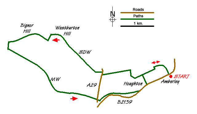
This South Downs walk includes parts of both the South Downs Way and the Monarch's Way. The route includes a mixture of fields, woodland, a few hills up and down. After wet weather the paths can be quite muddy. Care is also needed crossing a busy main road. Route finding is generally easy.
The start and finish point is Amberley station. After crossing the main road and going left under the railway bridge, the first turning on the right leads over a wooden stile to the River Arun. Cross the footbridge over the river on the left and then follow the waymarked signs for the South Downs Way. Once the path gains some height, there is a view looking back towards the River Arun and the footbridge and a stretch of the South Downs ridge to the east of Amberley. After crossing the busy A29 there are no more roads to cross for a few miles as the route heads north-west between fields.
The next dip marks a crossroads of paths near to Westburton Hill and then the next stretch is quite steep going up south west before turning north-west on the way towards Bignor Hill with its two radio stations. Looking back, you can see the path you have just come along across the valley to the east. The path does not go to the top of Bignor Hill but skirts round to the left of it and leads to a car park.
Turn left here off the South Downs Way and head the short distance south to meet the Monarch's Way. Turn left onto this long distance path and continue through woodland along "The Denture" and through Houghton Forest. Once the path crosses the main road (A29) it crosses alongside a field with a view overlooking Amberley. Rather than walk along the road turn left in Houghton (grid ref. TQ018115) and walk north to rejoin the South Downs Way used earlier. A footpath to the right leads back to the bridge over the river and then back to Amberley railway station.
Messaging & Social Media
Message Walking Britain and follow the latest news.

Mountain Weather
Stay safe on the mountains with detailed weather forecasts - for iOS devices or for Android devices.