Walk 1707 - printer friendly version
The Roaches short circular Walk
Author - Lou Johnson
Length - 5.0 miles / 8.1 km
Ascent - 800 feet / 242 metres
Grade - easy/mod
Start - OS grid reference SK006618
Lat 53.153334 + Long -1.9924829
Postcode ST13 8UA (approx. location only)
The Roaches are one of the dominant features of the North Staffordshire landscape especially those travelling between Leek and Buxton across the moors. A jagged escarpment of gritstone, the edge offers superb views across north Staffordshire, glimpses of Derbyshire and a long distance view of the Cheshire plain. This Peak District walk offers an excellent introduction to the area so choose your day carefully and make sure the weather does not spoil those views.
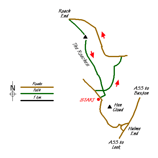
To reach the start leave the A53 Leek to Buxton road at Upper Hulme and follow the narrow lane that runs roughly northwest parallel to the Roaches. Parking is permitted on the roadside although there have been periods when a park and ride system has been in operation (check with the tourist office in Leek for up-to-date information). Ideally you need to park as near as possible to grid ref. SK006618 (opposite the col between Hen Cloud and The Roaches) adjacent to the footpath sign on the north side of the lane. If this is not possible then alternative parking along the lane will have to be used and on busy days this soon gets full.
After parking follow the footpath and climb steadily to the col. You reach a cross path linking Hen Cloud to the right with the Roaches on your left. Turn left and cross the grass to reach another path junction on the opposite of a wall (grid ref. SK006621). Turn right onto this path as it shadows the wall on your right. The path is easy to follow in the early stages although some careful navigation is required in the latter stages to bring you out onto a tarmac lane (grid ref. SK012632).
Turn left and follow this quiet lane enjoying views to the right that include the village of Flash (the highest village in Staffordshire), the North Staffordshire Moors, parts of Derbyshire and some of the high ground of Cheshire including Shutlingsloe (affectionately known as the Cheshire Matterhorn). Stay on the lane for just over 2 kilometres until you reach Roach End (grid ref. SJ995644). Leave the lane and turn left onto the partially flagged path that leads up to the Roaches. The going is easy and you soon are able to enjoy a wide panorama across Staffordshire and parts of lowland Cheshire.
Continue on the main path to reach the trig point from where you are able to enjoy the widest panorama of the walk. Having enjoyed the view continue southeast descending slowly across the moor. To your left are the gritstone crags that offer some excellent climbing. You may even see the odd head suddenly appear over a crag as a climber eases himself off his route on to level ground.
In places there is a choice of path. The choice is yours as they all eventually lead back to the col visited in the early stages of the walk. Reaching the wall (grid ref. SK006621) turn right and follow the path back to the lane where you have parked.
Messaging & Social Media
Message Walking Britain and follow the latest news.

Mountain Weather
Stay safe on the mountains with detailed weather forecasts - for iOS devices or for Android devices.