Walk 1730 - printer friendly version
Blakeney Point Walk
Author - Lou Johnson
Length - 9.0 miles / 14.6 km
Ascent - 240 feet / 73 metres
Grade - moderate
Start - OS grid reference TG044437
Lat 52.951723 + Long 1.04119
Postcode NR25 7RA (approx. location only)
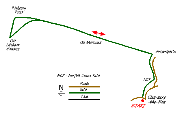
This walk starts from the attractive village of Cley-next the-Sea and follows the beach out to Blakeney Point. The route is straightforward although sections are across shingle beach so it is much tougher going than might be anticipated. The views are dependant on tides and there may be access restrictions in place during certain times of the year (mainly the breeding season) to protect the abundant wildlife in the Blakeney Point National nature Reserve.
The start is the village of Cley-next-the-Sea (Grid ref TG044437) opposite the 'Delicatessen' bus stop used by the Coast Hopper Bus Service. Almost opposite a waymarked path with the Acorn National Trail symbol leads you behind the backs of houses and past the windmill into open country. The path then continues alongside a road out to a car park (Grid ref. TG047452) and "Arkwright's Café" and the beach. This also provides a useful start for the walk for those with their own transport and saves about two miles of walking.
Turn left along the beach taking the easiest route. There is an information sign that provides useful background on Blakeney Point and its many attractions. Continue along the beach the Marrams (Grid Ref. TG028459). Across the channel you can see the villages of Cley and Blakeney. The view depends on tides, with high water producing vast expanses of water to your left. At low water it is a very different picture with mudflats dominant.
The beach gradually becomes more sandy and passing Long Hill on your left follow the indistinct path past the chalets to reach the old lifeboat house of Blakeney Point (Grid ref. TF998458). This is not marked on some OS maps but is indicated as being a telephone! Now owned by the National Trust there are toilets in season. From the old lifeboat house, walk north on the boardwalk back to the beach. Turn right along the beach and retrace your steps back to the start.
Note - There is an excellent bus service operating along the A149 coast road between Sheringham and Kings Lynn. Operated by Norfolk County Council, this 'Coast Hopper' service is useful for many walks as the bus route shadows the Norfolk Coast Path. This enables one way walks to be undertaken with relative ease but also means that other walks can be altered to suit your needs.
Messaging & Social Media
Message Walking Britain and follow the latest news.

Mountain Weather
Stay safe on the mountains with detailed weather forecasts - for iOS devices or for Android devices.