Walk 1805 - printer friendly version
An introduction to the Breamish Valley Walk
Author - Lou Johnson
Length - 2.0 miles / 3.3 km
Ascent - 495 feet / 150 metres
Grade - easy
Start - OS grid reference NU007163
Lat 55.440579 + Long -1.9904887
Postcode NE66 4LT (approx. location only)
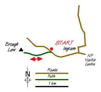
This very short walk is included to encourage you to explore the Northumberland National Park. It is an ideal brief excursion for those heading north or south along the A697 from Newcastle to Coldstream.
To reach the start leave the A697 on the road signed Ingram. Continue past the entrance to the National Park Visitor Centre and continue through the village. After about a mile there is a parking area with toilets on your right (grid ref. NU007163).
After parking cross the road and follow the track and path to the summit of Brough Law. The summit, a site of an ancient fort, is soon reached and provides excellent views in all directions. Of particular note is the view north-west to the Cheviot (the highest mountain in the area) although the valley and its immediate surroundings offer much of visual interest.
All that remains is to retrace your steps to the parking area although a competent walker equipped with an appropriate map will be able to extend the walk to suite their needs.
Messaging & Social Media
Message Walking Britain and follow the latest news.

Mountain Weather
Stay safe on the mountains with detailed weather forecasts - for iOS devices or for Android devices.