Walk 1832 - printer friendly version
The Hollies & Poles Coppice from near Habberley Walk
Author - David McMahon
Length - 5.0 miles / 8.1 km
Ascent - 600 feet / 182 metres
Grade - easy/mod
Start - OS grid reference SJ391027
Lat 52.6186370 + Long -2.9009714
Postcode SY5 0SG (approx. location only)
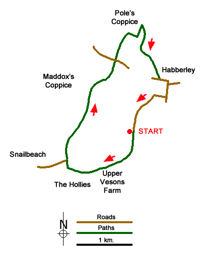
This Shropshire walk explores the area to the north of the Stiperstones and provides the opportunity to see the ancient Holly trees that are believed to be over 400 years old in the area marked as "the Hollies" on OS maps. The start is the small car park to the south-west of the village of Habberley located on the eastern edge of Eastridge Wood (grid ref. SJ391027).
After parking exit the parking area and turn left following a narrow lane southwest. After 400 metres you reach an open area and a junction of tracks (grid ref. SJ391023). Here take the track veering left, which leads to Upper Vessons Farm (grid ref. SJ387020). Bear left in front of the farm and then take the left-hand track which leads into the Hollies. It is worth exploring the area immediately south of the track to fully appreciate the historic Holly trees before returning to the track to continue west. Pass the small chapel on your left to reach a lane (grid ref. SJ380021). Reaching a T-junction, turn right and follow the lane. Ignore the first track on your right but continue round to the left and take the signed footpath on your right (grid ref. SJ380022).
This path leads into woodland emerging after 300 metres into a large field. Cross the filed with the boundary on your immediate right. The path follows the edge of woodland on your left before turning north through Maddox's Coppice. After 600 metres you reach a junction of tracks (grid ref. SJ384033) where you bear right and follow a track heading northeast. The track leaves the woodland and continues north to reach a lane (grid ref. SJ389039).
Go straight across the lane initially joining an enclosed path. This path continues across open fields to reach the southern boundary of Pole's Coppice (grid ref. SJ391044). Turn right and initially follow the edge of the wood. The path continues into the wood Reaching a path junction (grid ref. SJ392043), go left and follow the path for just over 200 metres to reach a bridleway. Turn sharp right onto this bridleway and follow it out of Lees Coppice towards the village of Habberley. Reaching a lane (grid ref. SJ396036). Turn right along the lane. At the next junction turn left and then bear left at the next junction almost immediately. After 250 metres turn right at the next junction. This lane leads back to the start which is a kilometre down this lane.
Messaging & Social Media
Message Walking Britain and follow the latest news.

Mountain Weather
Stay safe on the mountains with detailed weather forecasts - for iOS devices or for Android devices.