Walk 1858 - printer friendly version
Cissbury Ring and Chanctonbury Ring Walk
Author - Hugh Maguire
Length - 10.5 miles / 17.1 km
Ascent - 1520 feet / 461 metres
Grade - moderate
Start - OS grid reference TQ170106
Lat 50.883055 + Long -0.33816019
Postcode BN44 3LF (approx. location only)
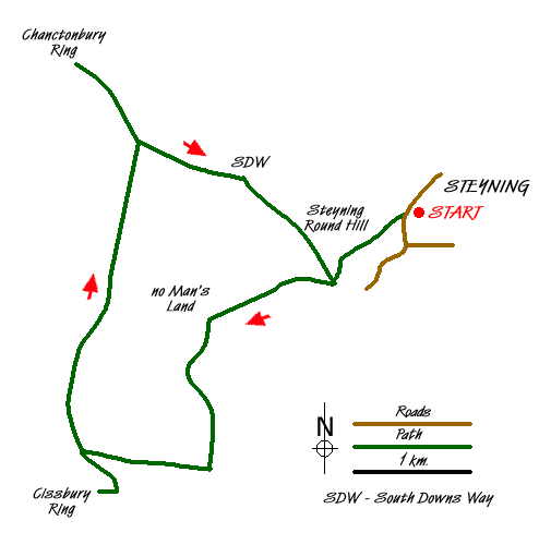
This West Sussex walk in the South Downs National Park explores some interesting country north of Steyning and includes the Iron Age Forts of Cissbury Ring and Chanctonbury Ring. The village of Steyning is approached using the A283 and is a beautiful Sussex village nestling under the South Downs. To park your car at the start of this walk you need to find a cul-de-sac at grid ref TQ170106. After parking, turn left out of the cul-de-sac, follow the road for a bit before taking the steep path south west straight up Steyning Round Hill. About halfway up is a gate and you keep on the path until you reach a bench where you turn left.
At the junction of paths (grid ref. TQ163100), where there is a sort of memorial, go west to No Man's Land and another junction of paths (Grid ref. TQ151097). From here go south down a beautiful valley until you reach a large track where you head west to the car park at the foot of Cissbury Ring (Grid ref TQ140085). From here it is an easy climb onto the ring, a circuit of which will offer a variety of views of the surrounding area.
Descend back to the car park and turn north. Follow a fairly wide track until you reach the South Downs Way (Grid ref TQ145114). From here an out and back walk to Chanctonbury Ring can be completed by turning left. Chanctonbury Ring is a small Iron Age hillfort that was use in various periods of history and is still a notable Sussex landmark. Located on a prominence on the northern edge of the South Downs, it overlooks a large portion of the Weald below with the old ridgeway across the downs passing just to the south.
After visiting Chanctonbury Ring, return east along the South Downs Way until you come to the junction of paths by the memorial (grid ref. TQ163100). Turn north here and make your way back via the bench and the car park to your car.
Messaging & Social Media
Message Walking Britain and follow the latest news.

Mountain Weather
Stay safe on the mountains with detailed weather forecasts - for iOS devices or for Android devices.