Walk 1959 - printer friendly version
Gray Crag and Pasture Beck from Hartsop Walk
Author - Lou Johnson
Length - 5.5 miles / 8.9 km
Ascent - 2200 feet / 667 metres
Grade - moderate
Start - OS grid reference NY410130
Lat 54.508859 + Long -2.9127286
Postcode CA11 0NY (approx. location only)
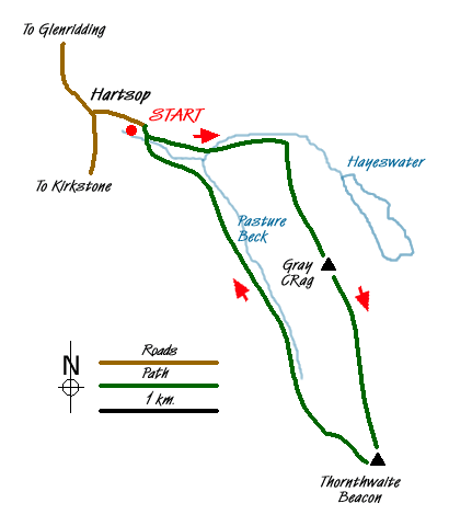
This short Lake District circular walk provides excellent views and great walking. The start is the pretty village of Hartsop where some cottages still retain their spinning galleries. The climb onto Gray Crag is steep but once this ascent has been completed the walk is relatively straightforward to reach Thornthwaite Beacon. A descent to Threshthwaite Mouth is followed by a beautiful valley walk alongside Pasture Beck back to the start.
There is limited parking at the end of the lane through Hartsop village (Grid ref. NY409130). From here walk up the track towards Hayeswater, keeping the extensive sheep-pens on your right. Descend to cross Hayeswater Gill by a bridge (Grid ref. NY416128). The track starts to climb with Gray Crag to your right. The start of the path is not too clear and some detective work is required at grid ref. NY420129 where you leave the main track and start the climb over grass. After a short way the route steepens and the path becomes clear. After the initial steep section the gradient eases and the route slants left across the end of Gray Crag before trending right to gain the ridge.
The bulk of the ascent is now over and the walking becomes easier with improving views in all directions across the Lake District. To the left lies High Street and to your right the parallel ridge of Hartsop Dodd. Behind lie Brock Crag, the Angletarn Pikes and Rest Dodd amongst other fells. Reaching the first summit you lose height before reaching a higher top (Grid ref. NY429110). After this there is a brief descent and all that remains is a short climb onto Thornthwaite Beacon with its large cairn. From here the views open up to the south with Lake Windermere a distinctive landmark.
The descent begins here with the path down to Threshthwaite Mouth heading northwest. The path is quite loose in places and makes this a rather unpleasant descent. However the view ahead to Caudale Moor does provide some compensation. Reaching the col (Grid ref. NY426102), turn right through the wall and descend into the u-shaped valley that is home to Pasture Beck. The first section of steep path has been improved in recent years and once this has been completed the remaining route is easy and relaxed.
All the way down the valley the slopes of Gray Crag dominate on your right as delightful Pasture Beck tumbles down the valley. Evidence of glacial activity in the past can be seen in the moraines scattered about the valley floor. Nearing Hartsop the path becomes a track which drops down to cross Pasture Beck over a stone arch bridge. On the other side turn left down the track and you are soon back at the start.
Messaging & Social Media
Message Walking Britain and follow the latest news.

Mountain Weather
Stay safe on the mountains with detailed weather forecasts - for iOS devices or for Android devices.