Walk 2033 - printer friendly version
Tilberthwaite & Wetherlam Walk
Author - John Paterson
Length - 5.0 miles / 8.1 km
Ascent - 2020 feet / 612 metres
Grade - moderate
Start - OS grid reference NY306010
Lat 54.399715 + Long -3.0705032
Postcode LA21 8DG (approx. location only)
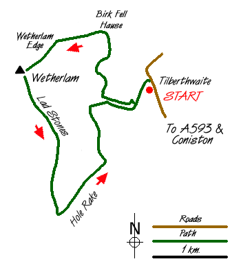
Wetherlam is often included as part of a horseshoe starting with Coniston Old Man or, from Little Langdale, in a circuit including Swirl How and Wet Side Edge. It is, however, a fine mountain in its own right and this Lake District walk of moderate length from the delightful hamlet of Tilberthwaite covers some varied terrain. The approach and the return are on excellent paths created by miners who worked the lower slopes hundreds of years ago and the impressive approach to the summit via Wetherlam Edge is in great contrast to the start and finish of the walk.
Leave the A593 Coniston to Skelwith Bridge road at Great Intake (GR 313996) just under 2 miles north of Coniston and take the minor road heading north west to Low Tilberthwaite which is reached after just under 1 mile. Park at the carpark (GR NY306010) just before the bridge over Tilberthwaite Gill.
Climb the steps leading out of the car park and join the miners track which climbs along side the south east (left) bank of the Gill. After passing various quarries and mine workings the path levels and a fork is reached. Fork right and follow the path as it drops down towards the footbridge crossing the Gill. The Gill is almost alpine in character with larch and rowan predominant. Cross the footbridge and climb steeply before turning left onto the path from the hamlet of Tilberthwaite. This path contours around the foot of the minor fell of Blake Rigg until it starts to climb steeply to Birk Fell Hause. At the Hause in clear weather there are excellent views down into Little Langdale and across to Blea Tarn and the Langdale fells.
At the Hause turn left onto a level path which steepens sharply as the ridge of Wetherlam Edge is reached. This is a surprisingly dramatic ridge, in complete contrast to the route so far. Several low rock steps have to be negotiated but nothing of any difficulty. In mist, follow the line of the ridge and the summit cairn is reached 100 yards after the ridge levels out.
Three routes meet at the summit. Our descent down Lad Stones Ridge heads due south for about 75 yards when it starts to veer to the left (south west) to follow the faint ridge line at an easy angle downwards. The ridge is not followed to its foot. After about half a mile it is possible to head further left and drop down to meet the miners track from Coppermines Valley to Tilberthwaite near Hole Rake (GR293991). Turn left onto the miners track and follow it back to Tilberthwaite. Before leaving, take the short walk along the road to Low Tilberthwaite. This is one of Lakeland's prettiest cottages with a barn and spinning gallery attached.
Messaging & Social Media
Message Walking Britain and follow the latest news.

Mountain Weather
Stay safe on the mountains with detailed weather forecasts - for iOS devices or for Android devices.