Walk 2037 - printer friendly version
Bowfell & Rosset Pike via the Climber's Traverse Walk
Author - John Paterson
Length - 7.5 miles / 12.2 km
Ascent - 3300 feet / 1000 metres
Grade - hard
Start - OS grid reference NY286060
Lat 54.444365 + Long -3.1025093
Postcode LA22 9JY (approx. location only)
For every 100 walkers who climb Bowfell by the "tourist" route via Three Tarns only one climbs it via the Climber's Traverse and the Great Slab. This is a pity as this is Lake District walk of very high quality and interest. The first thing to realise is that you don't have to be a climber! It got its name because it was devised by climbers as a way of reaching Bowfell Buttress and it is not difficult. Secondly, when negotiating the Great Slab, follow the route instructions in the text below and you will be perfectly safe in very dramatic surroundings. This is the best way up one of the finest mountains in the Lakes with superb views en route.
Start at the Old Dungeon Gill car park at the head of Langdale. This is pay and display, so take some cash and arrive early as there is no roadside parking near ODG. Note: Parking is cheaper for under 4 hours but most people will need more than that for this route.
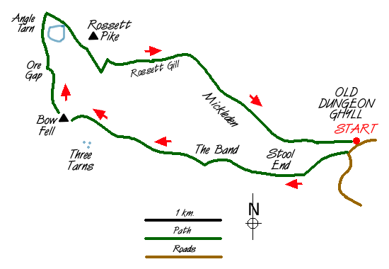
Leave the car park, turn right and walk along the road for a few yards until the signed track to Stool End is seen to your right. Proceed for half a mile to the farm. Immediately after passing though the farmyard turn right onto a smaller track which climbs steeply up the broad ridge of the "Band". Extensive footpath restoration has made this less of a slog than in years gone by but it is still hard graft for over a mile until the ridge levels out and the path ahead can be seen rising to the col at Three Tarns. As soon as this path is seen (from GR255063), look to the right to pick up the line of a fainter path which heads more steeply up the fellside (see picture 2 above). Follow it on a rising traverse until you are at or just slightly above, the level of the Three Tarns col. The route turns right and climbs up easy rock steps to a shoulder. The Climber's Traverse is seen as soon as you pass over the shoulder (picture 3 above).
The traverse is narrow and undulating but not difficult with just the occasional easy rock step. The views are impressive but the sense of exposure is not too great. The traverse aims for the foot of the tower of Bowfell Buttress about a quarter of a mile ahead. Two cliffs lie above the approach to the Buttress. First, Flat Crags and then Cambridge Crags which can be recognised by the spring gushing out from the rock. Once the spring is reached (about 50 yards short of the Buttress) face the crags and look to the left to see what "Wainwright" described as a river of boulders. Scramble up these boulders for a few yards until it is possible to step onto the Great Slab to your left and climb up its near edge (at an angle of about 30 degrees) using the boulders for occasional hand and footholds. Under no circumstances should you move away from the boulders onto the middle of the slab - stay by the right edge and you will be quite safe. The slab is climbed for about 200 feet until the boulder slope becomes a gully which is followed to join the main track from Three Tarns leading to the rocky summit less than 200 yards away. The summit views in all directions are good but the view of the Scafells is exceptional.
Leave the summit heading north on a rocky path to Ore Gap (GR242072), named after the red vein of Haematite ore which stains the surface. Turn right here and drop down to Angle Tarn. From the Tarn make the short climb to the top of Rosset Pass where a detour of 200 yards to the left will take you to the summit of Rosset Pike. Return to the top of the pass. Ahead lies the stone filled gully of Rosset Gill which is most suitable for masochists! If you prefer a gentler descent, look to your right before the gill to see the start of the packhorse route which wends its way down the fellside at a much easier angle. There are two other benefits of taking this option. First, there are superb views of the north east face of Bowfell giving you the chance to see again the highlights of the walk (see picture 9 above). Second, if you are lucky you may see the "pack woman's grave" marking the final resting place of a woman who spent many years guiding pack horses across the pass. The track rejoins the gill just above the flat valley floor of Mickleden. Two miles easy walking back to ODG, but it may seem longer to tired legs!

Mountain Weather
Stay safe on the mountains with detailed weather forecasts - for iOS devices or for Android devices.

