Walk 2063 - printer friendly version
Watership Down and Ladle Hill from the Sydmonton Estate Walk
Author - Peter Lane
Length - 4.5 miles / 7.3 km
Ascent - 500 feet / 152 metres
Grade - easy
Start - OS grid reference SU477582
Lat 51.320913 + Long -1.3168878
Postcode RG20 9NH (approx. location only)
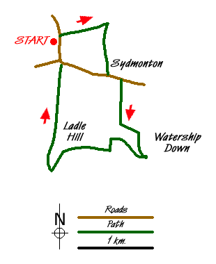
A delightful short walk that features a fantastic section of the North Downs on the renowned Watership Down made famous by the eponymous novel about rabbits! The walk also features the incomplete iron age fort on Ladle hill and the genteel Sydmonton Estate. Views from the ridge (now forming part of the Wayfarer's Walk) are superb.
The walk commences near Wergs Farm, grid reference SU477582. Park on the side of the road, just before the farm if heading North towards Burghclere. Head North towards the farm and then after the farm buildings turn right along a broad track with superb views to the North up to Watership Farm. Take the first turn right down another broad track that passes paddocks, tree lined avenues and the impressive stately pile itself. Upon reaching the road through Sydmonton, turn left and after a few metres take a hedge-lined track that heads straight for the imposing Downs ahead. Ladle Hill is to the right, its fort hidden from view from below.
The track veers off left as it rises. Follow it as it turns into a tree lined lane with spectacular views into the valley below and Watership Down to the left. Upon reaching the crest, turn right onto the Wayfarer's Walk and follow it as it twists right then left towards the edge of a wood. At the end of the wood through a swing gate turn square left and follow the track as it turns square right passing a tumulus (ancient burial mound). The path climbs to the fenced off summit of Ladle Hill, an incomplete Iron Age Hill Fort. Explore this at your leisure and then return to the path.
At the end of the fort, the path turns left and descends slightly. The return route is marked with a waymarked post and a cairn. This bridlepath turns right at an acute angle, heading for the woods below. Enter the woods and follow the enclosed path all the way back to the start point. Note the view of Beacon Hill, highest point in Hampshire, by the A34 to the left.
Messaging & Social Media
Message Walking Britain and follow the latest news.

Mountain Weather
Stay safe on the mountains with detailed weather forecasts - for iOS devices or for Android devices.