Walk 2073 - printer friendly version
Harrison Stickle, Pike o'Stickle & Rosset Pike Walk
Author - Peter Smyly
Length - 8.3 miles / 13.4 km
Ascent - 2800 feet / 848 metres
Grade - moderate
Start - OS grid reference NY296064
Lat 54.448099 + Long -3.0871875
Postcode LA22 9JX (approx. location only)
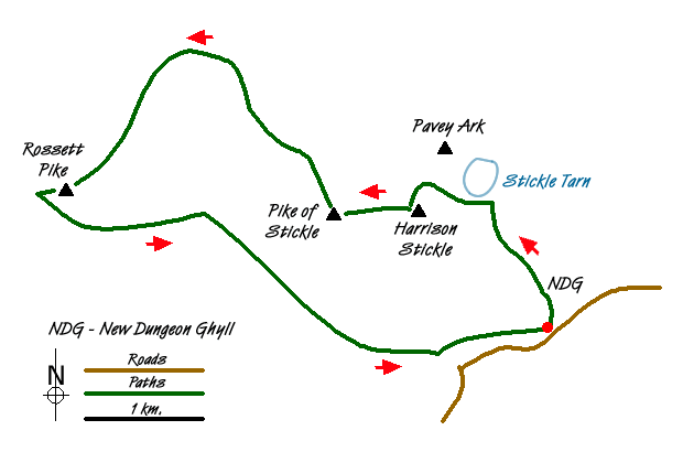
This excellent Lake District walk starts from the car park at the New Dungeon Ghyll Hotel, a well-constructed stone path leads the way upwards, passing the beck on the right and with Pavey Ark showing ahead on the right with Harrison Stickle on the left. For the most part, the route up to Stickle Tarn is obvious but there is one point where a choice will have to be made concerning the ongoing route. A few minutes from the tarn, the path crosses Stickle Beck from right to left. The choice is either to pick your way across rocks, a straightforward enough task for most, or to clamber up steeply to the right and follow the way up to the tarn from there.
Either way, Pavey Ark dominates the view ahead and the rushing waters of the stream beyond the dam announce that Stickle Tarn is about to appear. The tarn is a good place to stop for a while and admire the cliffs of Pavey Ark and the diagonal traverse of Jack's Rake.
From the dam, a path goes to the left and then right as it heads up Harrison Stickle. Looking across to Pavey Ark, you may be able to spot some walkers scrambling up Jack's Rake. The top of Harrison Stickle commands fine views in different directions including a look down the Great Langdale valley way below.
The next summit, the dome-shaped Pike of Stickle is clearly in view to the west and the descent is quite steep off Harrison Stickle before the ground levels out and then a gentle path leads towards the next objective. Look out for a scree slope to the left that goes all the way down to the Mickleden valley below, though it is not recommended as a descent route. The climb up to the top of Pike of Stickle involves some basic scrambling in places and the last time I was there, someone had left an upturned spade in the summit cairn (see photo). "A view to die for" was how one fellow walker in another group described the summit view on this occasion.
Rossett Pike, the third summit on the walk, appears dwarfed by Great End from Pike of Stickle. Next, head due north west and the path is intermittent in places but the right direction clear as you pass Martcrag Moor and the Stake Pass. The latter offers a way of cutting the walk shorter by omitting the third summit and taking a more direct route to the descent down part of the Cumbria Way to Mickleden. Down into the dip the path goes and then relatively steeply up the other side. The top of Rossett Pike is a rocky one and it offers a fine view of nearby Bowfell in particular.
Descending to the col between Rossett Pike and Hanging Knotts, a glimpse of Angle Tarn can be seen. The path down Rossett Ghyll towards Mickleden is generally steep and rocky and calls for careful footwork. Eventually, the gradient eases off and then begins the long walk back down Mickleden. I have heard some people say that Mickleden seems to go on forever and it can feel like that. The path passes Middle Fell Farm leading to a tarmac road and then it is simply a question of following the road back down the valley to rejoin the car park at the start point of the walk.
Messaging & Social Media
Message Walking Britain and follow the latest news.

Mountain Weather
Stay safe on the mountains with detailed weather forecasts - for iOS devices or for Android devices.